Total Pageviews

Thursday, May 31, 2012

Gold Occurrences in South Africa


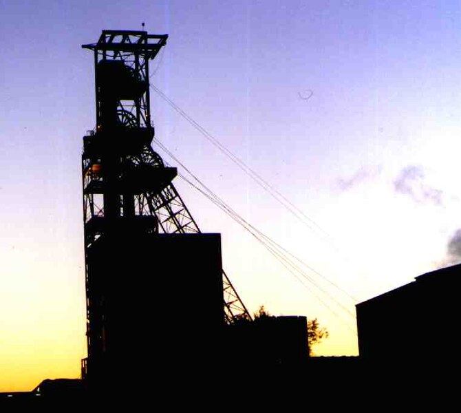
The headframe of a gold mine in Reef City, South Africa
Photo by Nolween


More then 40% of all the gold ever mined has come from the Witwatersrand commonly called “The Rand” since 1870.  The deepest mines in the world are also found in The Rand.  In 2005 it accounted for 12% of the total world’s gold production, but as late as 1993 it accounted to over 30% of the world’s gold.  Overall it has been estimated that greater then 50% of the world’s gold reserves are from South Africa with 40% from the Witwatersrand alone.

The word Witwatersrand in Afrikaans means the ridge of white waters a large range of sedimentary hills in the northeastern part of South Africa.  The range has a height ranging from 1,700 to 1,800 meters although it appears lower then that because its relief is low and the heights are because it is on top of a large mountain plateau.  The ranges run from east to west mainly in the Gauteng province of South Africa.

Geologically it is quite complex composed mainly of quartzites, quartz pebble conglomerate and shale.  These rocks are geologically turbidites that flowed down a Precambrian continental slope.  The Witwatersrand gold and uranium deposits for years have been the center of a controversy as to where they came from.  The controversy was apparently laid to rest with the discovery by analyzing some of the platinum group metals that determined they came from a long lost mountain range to the north.

The rocks of the “Rand” or reef are similar to those found at Elliot Lake and Timmins, Ontario and are very rich in gold and uranium.  So famous is the name Rand even South Africa’s currency is called a Rand.  The name Witwatersrand also attaches itself to the Greater Johannesburg Metropolitan Area.

Gold was discovered in the Rand as early as July 31, 1826 by Peter Jacob Marais on the banks of the Jukskei River; the find was kept secret at the time.  Gold mining really started on the Rand in 1886 although there were sporadic efforts before that.  The Rand sparked a gold rush in the Witwatersrand and later deposits of gold and uranium eventually created the largest urban area in sub-Saharan Africa.

Among the many gold mines in South Africa are two of the world’s deepest mines.  In the East Rand Mine at Boksburg reaches a depth 3,585 meters.  The TauTona mine in Carletonville is 13 meters less then the East Rand Mine.  Plans are afoot to work on an extension of the TauTona mine that will bring its total depth to more then 3,900 meters (12,800 feet). This will break the present by 39 meters (127 feet).  When you get to these depths the rocks can reach 60o C (140o F).

The Homestake Gold Mine of South Dakota


The open pit portion of the Homestake Gold Mine in Lead, South Dakota.  This is only a small part of the mine because it extends into the earth for thousands of feet making it at one time the deepest mine in the western hemisphere.
Photo by Rachel Harris


This mine traces its origins all the way back to 1876 when it was discovered by Fred and Moses Manuel, Alex Engh, and Hark Harney in April, during the Black Hills Gold Rush.  The following year it was sold to a trio of gold entrepreneurs, George Hearst, Lloyd Tevis and James Ben Ali Haggin who bought the mine from the group that discovered it for the sum of $70,000.  In October 1877 George Hearst appeared at the scene of the mine where he took active control.  All the mining equipment used at the mine had to be hauled in by oxcart from the nearest railhead in Sidney, Nebraska.  Even though the mine had a remote location by July 1878 the 80-stamp mill started to crush the ore from the mine.

The mine is located in a domal uplift that is about 100 kilometers long and 60 kilometers wide straddling the border of South Dakota and Wyoming.  The Black Hills were uplifted during the Laramide orogeny that occurred between 60 and 65 million years ago, and are an outlier of the Rocky Mountains.  The rocks exposed in this range are from 2.7 billion years old to 60 million years old.  The core of the mine is composed of Precambrian phyllite, cummingtonite schist and granite with the Black Hills surrounded by younger sedimentary rocks.  Most of the gold deposits are associated with a Precambrian banded iron formation.

Hearst and his partners sold shares in the Homestake Mine and had it listed on the New York Stock Exchange in 1879 where it is too this day as one of the longest-listed stocks on the exchange.  The stock that has been listed the longest is Con Edison, whose original name was New York Gas Light whose listing dates back to 1824.

Under their control the mine’s holdings were increased sometimes by fair means or if that didn’t work by foul means.  They bought out some of the adjacent claims, but weren’t adverse about using the courts to obtain others.  There is even evidence that one man was murdered by one of the group’s men because he refused to sell his claim to them.  The case was dropped when all the witnesses to the murder vanished.  Hearst bought out the newspaper in Deadwood to sway public opinion his way, with the editor of the opposing newspaper was beaten up while walking down a Deadwood street.  Hearst himself realized that he could be murdered and asked his partners to take care of his family if he was; in the end though it was Hearst that walked away smiling, still alive and very rich.

Although the gold ore mined at Homestake was always low grade averaging less then an ounce per ton it existed in vast quantities.  During its lifetime the mine produced 39.8 million ounces of gold along with 9 million ounces of silver.  The mine is the only one in the Lead mining district was the second largest producer of gold in the United States.  The largest producer of gold is the Carlin Trend in Nevada.

At the end of 2001 production at the Homestake ceased for several reasons including low gold prices, poor ore quality combined with high operating costs.  There had been a merger with Barrick Gold Corporation and Homestake Mining Company in mid-2001.  They agreed to keep the mine dewatered while negotiations for its further use continued with DUSEL, but progress along these lines continued at a snails pace.  As negotiations dragged on it was costing Barrick $250,000 for maintaining the pumps and ventilation system so on June 10, 2003 Barrick threw the switch and closed the mine completely.

After being closed for six years researchers at Berkeley announced that the Homestake Mine would be used as a research facility causing it be reopened for the study of neutrinos and dark matter particles.


Monday, May 28, 2012

The Lost Dutchman Gold Mine


Weaver's Needle in the Superstition Mountains where the Dutchman hid his gold.
Photo by Alan English


Of all the lost mines in America the most famous is the Lost Dutchman Gold Mine that according to its legend is hidden away in the Superstition Mountains located near Apache Junction, east of Phoenix, Arizona.  Other people claim its way past the Superstitions in Mexico.  No one really knows where the mine is located.

The Superstition Mountains can be divided into three distinct groups that can be divided into (1) rock type, (2) structure and (3) process.  Most of the rock type consists of volcanic extrusives that are associated with volcanism.  The structure is consistent with the landform types found accompanying volcanic action and tectonic activity.  This is just the place where you would go looking for gold.  Erosion and mass wasting account for any placer gold that is present.  There are some small areas of sedimentary and metamorphic rocks as well as some Precambrian granite intrusions to be found.  Most of the volcanic activity is from fissure eruptions rather then volcanoes.

Another view of Weaver's Needle
Photo by Ihelewa


The Lost Dutchman Gold mine that is also known by many other similar names is the tale of a very rich gold mine hidden away in the Superstition Mountains, but because Jacob Waltz, the Dutchman, kept the secret of its location to himself.  There are several different tales about how to find the mine and each year there are people that go hunting for it.  Some of these gold seekers have even died in the process.

The mine itself was named after the German immigrant Jacob Waltz that the locals mistakenly called the “Dutchman” that was American slang for a German.  This is derived from the German word for German – “Deutsch.”  The Lost Dutchman is no doubt the most famous lost mine in American history rivaling tales of Captain Kidd’s lost treasure or the Lost Pegleg Mine in California.

Prior to Waltz’s reported discovery in the 1840s the Mexican family, the Peraltas were reported to mine gold in the Superstitions where in 1848 a large group of the Peraltas was ambushed by the Apaches with only one or two members escaping.  There is plenty of evidence of this massacre to be found in the Massacre Grounds where old mining equipment, old weapons, assorted gear and the remnants of a pack train have been found.

The legend goes on to say the Peraltas covered the mines with large rocks to hide their riches from others.  Since then many men have claimed to have found the hidden mines from the number of old maps that have surfaced.  However the men making such claims are unable to return to these mines due to any number of calamities and disasters.  These tales lend truth to the tales of the “Curse of the Superstitions.”

During the 1970’s “the Dutchman” aka Jacob Waltz supposedly found one of Peralta’s gold mines with his partner Jacob Weiser another German.  The story goes on to say they hid some of the gold they found in the area around Weaver’s Needle.  Later Weiser was killed either by the Apaches or Waltz himself.

Waltz later moved to Phoenix where he died in 1891.  Before he died he described the location of the mine to Julia Thomas his landlady.  She became one of the first treasure hunters in 1892, she or other treasure hunters have never been able to find the lost mine since.  Many of them came to a sudden end due to foul play, murder, death or the curse hanging over the Superstition Mountains.

It has been estimated that 8,000 treasure seekers a year have been looking for the Dutchman’s mine since 1892.  Many claim there is no basis to the tale and it is nothing more then a legend, although it is claimed there is some basis in fact to the tales.  Many versions of this tale claim the mine is either cursed, or protected by some kind of guards, usually the Apaches that keep the location of the mine secret.


Friday, May 25, 2012

The Lost Doukobor Mine


Argentite aka Acanthite
Photo by Rob Lavinsky


In autumn of 1929 lightning struck in Gold Creek Basin and started a forest fire in the area behind Hubbard Ridge, to the north of Flagstaff Mountain.  Although the fire was in Washington State the nearest crew for fighting the fire was a crew of twenty-five Doukobors from Rossland, British Columbia.  The Doukobors were a religious sect that migrated from Russia mainly during 1899 that were mainly farmers, but many of the men worked on the railroad while their women did the actual farming.

While the Doukobors were fighting the fire it jumped their fireguard and engulfed their camp in flames.  The firefighters ran for their lives.  Once the fire was finally extinguished they conducted a headcount and discovered two of their crew was missing.  The next morning the missing men rejoined their crew.

The Doukobors told the rest of their crew how they had managed to keep ahead of the flames.  During the night they took shelter at the base of a landslide where they discovered a vein of galena, an ore of lead and silver.  The men took samples of this ore that they brought back with them.  One of the workmen named Ray Wiley recalled later, “It was fine grained argentite – high grade silver ore.

The ore was sent to the CM&S Company’s assay office in Trail, British Columbia where it was assayed at over 1,000 ounces of silver per ton, thus it was bonanza ore.  Later in 1930 the Doukobors in company with some geologists returned looking for the rich vein of galena at the foot of a landslide.  They were unable to find a trace of the silver ledge, nor even the landslide.

Since that time many other prospectors have searched in Gold Creek Basin for the lost Doukobor Mine, but all their attempts to find the galena bearing ledge have failed.

Thursday, May 24, 2012

Peter Janni’s Silver Chimney


Tetrahedrite
Photo by Rob Lavinsky


This story sounds almost like it is untrue, but if you’ve ever worked for an old country contractor you know you can’t tell them anything.  The principal character in this tale was a one Peter Janni that was born in Italy in 1874 that eventually came to America to work on the railroad.  Eventually he fetched up in Northport, Washington where he proceeded to buy a limestone quarry just south of the town.  Janni sold limestone all over the state of Washington out of his quarry.

This quarry is located in the tetrahedrite zone in northern Stevens County.  The ore deposits are found in vugs and a structure called a chimney where narrow veins of galena bearing large percentages of silver are sometimes found.  In 1953 the quarry workers at Janni’s quarry found such a chimney that measured roughly 5 x 6 feet on the second level of the quarry.

The workers followed the chimney down and shipped almost forty tons of ore to the lead refinery owned by the CM&S Company in Trail, British Columbia.  Once they had reached down the chimney for fifteen feet Janni came over to where they were working and told the men to, “Cover the damn thing up.”  The men pleaded with Janni to let them continue following the chimney, but Janni refused telling them, “Maybe someday we will dig her up again.”

Nobody has any idea what got into Janni’s head that day, but according to some old timers still living in Northport this rich chimney is still in the quarry where it is it is buried under tons of limestone still on the second level.

The Lost Gold Ledge in Danville, Washington


Mt. Baker, Washington
Photo by Adam Lindsay


The town of Danville, Washington nestled right up against the Canadian border had a checkered past to say the least.  It started as Nelson, Washington, but the railroad changed its name to avoid confusion with Nelson, British Columbia.  The town had a store with entrances opening into both countries that the authorities closed down because of suspected smuggling.  The heyday of the town came with prohibition when many of its residents worked as guides for the whiskey smugglers guiding them over back-country trail out of sight of the revenuers so they could smuggle Canadian whiskey into the United States.  Once prohibition was over the town slowly faded away.

Before prohibition though in 1912 a prospector named John Falconer was working in the town during the summer as a laborer.  At some point a vicious thunder storm hit the area and a bolt of lightening set fire to a tree on the hillside southeast of the town.  Falconer rode a horse out of town along a game trail to put the fire out before it spread.  On the way it started raining and somewhere along the trail his horse trod on a rock sticking up from the ground.

By the time he reached the blazing tree the rain had put out the fire, so with nothing more he could do there he started back to town.  When he reached where his horse had scrapped the soil from a rock he could see it was full of pyrite so he stopped to get the rock.  It was not until several months later that Falconer realized the rock was full of gold not pyrite.  The gold slab was worth over $1,000 that contained over 50 troy ounces of gold that at the time was selling for $20.67 per ounce.

Around Danville the old timers called it “the golden plate” and thought it was only a small part of a gold ledge.  Falconer and his wife hunted for the place where his horse struck gold, but never could find the place again.

Since then many have looked for Danville’s golden ledge in the hills south east of the town but have never found it either.

It makes sense that there is gold there because it is close to the Cascade Mountains that supplied the heat necessary for the formation of gold deposits.  Two volcanoes that could have supplied the gold deposit are Mt. Baker in Washington and Mt. Garibaldi in British Columbia.


Tuesday, May 22, 2012

The Mine that made America


Portrait of George Washington - Peale 1776


By the looks of the place today you’d never suspect that Salisbury, Connecticut made it possible for us to be a free nation rather then a colony of Great Britain this was because nestled in the hills of Salisbury was a deposit of iron ore so rich they mined it for almost two centuries from 1736 to 1923 when the mine suddenly was flooded by rushing waters.  The mine itself never did produce any gold but it did produce the best iron ore in the world, and this iron was perfectly suited for the production of cannon.  In fact they called it ordnance iron.

The iron deposits at this mine called “Ore Hill” hundreds of millions of years ago when an island arc formed in the Iapetus Ocean, the father of the Atlantic Ocean, off the east coast of what then was North America.  From these volcanoes rained eruption debris that rained down onto a vast coral reef that fringed North America forming a sediment made up of volcanic ejecta and weathering products from island arc.  The island arc was very similar to today’s Japan that formed a back arc basin between the islands and the mainland similar to today’s Sea of Japan.

This sediment was very rich in iron, and was also interbedded with limestone that eventually underwent metamorphism during the Taconic Orogeny forming the Walloomsac formation of schist stretching along the eastern border of New York State from Vermont to New York City where it underlies the New York Stock Exchange.  Throughout its length this formation is studded with rich iron deposits like plums in a plum pudding.  There were many iron mines along its length with the largest at Ore Hill in Salisbury, Connecticut.  Year’s later scientists from the Smithsonian Institute in Washington declared the ore from Ore Hill was the finest ore in the world.

It was in 1728 when a group of surveyors from Hartford that first noted the presence of iron in Salisbury, but it was Ezekiel Ashley and John Pell from nearby Sheffield, Massachusetts that discovered the ore on Ore Hill in 1731.  Mining began almost immediately with the ore going to a furnace established by Robert Livingstone in Ancram, New York seven miles to the north.

The Salisbury blast furnace was built by Ethan Allen of Ticonderoga fame, Samuel and Elisha Forbes and Col. John Hazeltine built the first blast furnace in Salisbury at the outlet of the lake in Lakeville.  The furnace changed hands several times finally falling into the hands of Richard Smith an Englishman who also had a “Finery” in Robertsville, Connecticut, the first place in America to make steel on a commercial scale.  Smith was in England when the Revolutionary War broke out forcing him to stay there until the war was over.

The Connecticut Colony seized the mine and furnace in the name of the Committee of Public Safety and the governor of Connecticut, Jonathon Trumbell persuaded Squire Samuel Forbes to come out of retirement to cast cannon for the colonial army.  Squire Forbes agreed, and in the first six months of the war cast 850 tons of cast iron cannon for
George Washington.  Throughout the war the Salisbury Furnace cast around 850 cannon ranging in size from four pounders to thirty-four pounders.  None of them ever burst!  The rest of the colonies produced six cannon most of which burst when they were fired.  

Molly Pitcher swabbing a cannon made at Salisbury, Connecticut - The Arsenal of Democracy


When George Washington took over command of the Continental Army there were a total of six cannon in the whole thirteen colonies, and they were up against the British Army the most powerful in the world at the time that had plenty of cannon of all sizes.  Were it not for the effort of the iron workers from Salisbury the chances of beating the British Army and gaining independence were virtually nil.

The mine went on to produce the guns and fittings for the USS Constellation and Constitution that fought in the war of 1812.  The mine produced the iron for the US Arsenals at Springfield, Massachusetts and Harpers Ferry, Virginia.  Later the same mine produced the iron that made railroad wheels that put the entire nation on wheels, and a good share of the world too.  The final moments for the mine were when it flooded with a sudden inrush of water in 1923.  Today the mine is a small pond on the right side of Rt. 44 between Lakeville and Millerton, New York.

For a more detailed discussion see: http://salisburyirondistrict.blogspot.com/


Sunday, May 20, 2012

The Copper Mine in Bristol Connecticut

Bornite was the principal ore produced at Bristol, there are museum class specimens all over the world from this source.
Photo by Ra'ike

The copper mine at Bristol, Connecticut started in 1937 and continued in dribs and drabs until 1953.  It is a study in how not to operate a mine.  The owners always managed to spend more of their shareowners money then they could get out of the mine.  This mine was located along the contact between the Mesozoic sandstones of the Hartford Basin and the schists of the western uplands of Connecticut.  World class specimens of chalcocite and bornite much to the consternation of the operators were collected at the mine that are still found in many museums and in the hands of private collectors.

The early part of the 19th century was marked by many mines in Connecticut, the latest survey by the Connecticut Geological and Natural History pegs the number at over six-hundred, an online source has raised this to 1,246 mines.  The first mention of this mine was by Shepard in 1837, but later it was noted by Percival in 1842.  The mine itself lies about 4 miles northwest of the center of Bristol at an elevation of around 350 feet.

Although work on the mine began in 1837 it was worked in such a desultory way that only about 125 tons were shipped to England for refining.  From 1847 to 1853 the mine was at its most active and was more vigorously worked.  It was during this period that over half a million dollars were spent developing the mine.  The workings were extended to 240 feet and to 500 feet along the vein.  This and other tunnels gave the mine a maximum width of 120 feet.

During the same period the mine produced nearly $200,000 worth of ore weighing 2,200 tons with the picked ore having a copper content of 33%.  For years the mine was abandoned after the collapse of a heap of mine tailings destroyed a dam on Poland Creek precipitating a wall of water that almost wrecked the Forestville part of Bristol.

The mine was originally discovered by a farmer, one Theophilus Botsford became curious about why a spring on his property ran green, so he took a plow and team and uncovered a vein of copper ore.  Sure enough this was the source of the green water that stained the rocks in Poland Creek and killed the vegetation along the brook.  Finding the copper ore satisfied his curiosity and it wasn’t until 1800 when Asa Hooker, a brass founder in Bristol leased the land from the widow Sarah Yale.  She was a descendent of the founder of Yale University in New Haven.  She made a deal to be paid a percentage of any ore mined, but there was little mining done until 1836 long after she had died.

After 1836 the mine was worked on a large scale but never made a profit eventually falling into the hands of John M. Woolsey of Yale.  Under the hands of Prof. Silliman who was a good professor, but a lousy miner caused the most extravagant schemes and experiments were undertaken.  Hundreds of thousands of dollars were poured into the mine with far less coming out with the Bristol Mining Company that was incorporated in 1855 was bankrupt by 1857.

According to the Tunxis Valley Herald for December 17, 1886.

"The collapse which came was caused by the grossest mismanagement, and
not from any fault in the mine. The manager's crowning impulse seems to have
been to spend the most money in the shortest possible time. Large and expensive
buildings were for some trivial cause torn down and used for fuel, and new ones
erected which if reports are true, were liable to meet a similar fate.
"The agent resided in Farmington Street and kept eight or ten fast horses
at his stables in Farmington and others at the mine. The superintendent occupied the house near the mine. The office furniture and fittings were of an expensive style. Once a dance was given in the store room which had been provided with steam pipes for heating it on this occasion as it was winter. Sibley*s Band, of Hartford, the best in the State at that time, was hired for $100; the supper was a costly one, wine of several kinds being  furnished. That this wine was not an imitation may be  inferred  from the  f a ct that those at the  supper table amused themselves by throwing turkeys and chickens at each other.”

The mine also had gold that was associated with the copper ores.

The Tilly Foster Mine


The Tilly Foster Mine as it appears today.


This isn’t a gold mine instead it was an iron mine and where my great-grandfather went to work when he first arrived in the United States after leaving Nova Scotia for poaching gold on the Queensland.  He left his wife and child behind in Halifax, Nova Scotia intending to bring them down to the States as soon as he earned enough money.  These events started in the spring of 1870 at the mine he worked as a mine rigger a job he had done earlier in Glace Bay.  Much of the work was stonemasonry, a job he pursued for the rest of his life.

The Tilly Foster Mine itself is today an abandoned iron mine that was the most active during the 1970s that is about two miles west of the village of Brewster, NY.  The mine is now filled with water, and is surrounded by a junk yard.  The mine was named after Tillingham Foster who bought it from George Beale that owned the land where it was located.  After he died in 1842 the mine site passed through several hands until it finally came into the possession of the Harvey Iron and Steel Company.  The mine finally opened in 1853.  After its opening it employed large numbers of Irish and Italian immigrants.  These workers were known by numbers since they had names that were too hard to pronounce by the “Apple Knockers” that owned the mine.  My great-grandfather must have been the only Scotchman working in the mine.

Chondrodite on magnetite from the Tilly Foster Mine
Photo by Rob Lavinsky


The main minerals produced from the mine were magnetite and chondrodite from a mine that employed 300 workers and reached a depth of 600 feet (180 meters).  At the height of its production they were producing 7,000 tons of ore a month where after mining it was shipped by train to New York City where large amounts of it were trans-shipped to Scranton, Pennsylvania where it was made into rails by the Lackawanna Steel Company for use on the Delaware-Lackawanna Railroad.

After reaching a point where it was no longer feasible to operate it as an underground mine it was converted into an open pit mine during the years 1887 to 1889.  In 1895 a major collapse occurred that killed thirteen miners.  The collapse of the mine spelled its death knell and it was flooded by a nearby reservoir that supplied New York City with drinking water.

In its day it was the largest open pit mine in the world that collapsed in 1895 killing thirteen miners when tons of rock came crashing down on their heads.  Many of these miners were only known by their numbers.  The cave-in of the Tilly Foster Mine was caused by heavy rains that soaked into a mass of soapstone near the surface of the mine.  The mine was described as a funnel shaped oval hole in the ground that at the time of the collapse was 400 feet deep.

During World War II the abandoned mine was pressed into service by the military where it was used as a site to test and train with diving equipment.  A collection of minerals and other artifacts from the mine can be seen at the Southeast Museum in Brewster, New York

Friday, May 18, 2012

Lost Mines at Austerlitz. New York


Bash Bish Falls just south of Austerlitz


There are reports of a lost mine or two in Austerlitz, New York in Columbia County located in the high peaks of the Taconics.  According to reports the mine wasn’t profitable because there were only a few streaks of yellow gold to be found in the massive quartz.  Geologically this makes sense because the author has seen a lot of this quartz as float in the streams of Columbia County in the past.  There are also outcrops of the same quartz veins to be found throughout the county especially on the New York Thruway, the Berkshire Spur (I-90) and Rt. 22 in several places especially in Petersburg, New York.

According to the story Oscar Beckwith who had been born in the area around 1810 who had traveled extensively in the American West returned home at the age of 67.  Soon, Beckwith found traces of gold on his property he sought financial backing from a resident of the county named Simon Vandercook by making him a partner.  This new partnership didn’t work out to well and they soon took to quarrelling until in 1882 Beckwith solved the problem by murdering Vandercook.  This was a particularly grisly murder that also included cannibalism in Beckwith’s attempts to hide the murder.  He ate Vandercook’s liver after frying it in a frying pan.  He then cut the body up and prepared it for pickling in a barrel of salt brine, and the charred remains of Vandercook’s skull were found inside the kitchen stove..

He then disappeared for six years following the murder thus escaping justice, but he was eventually found and brought to justice.  Beckwith soon confessed to his crime where he described bludgeoning and stabbing Vandercook then started eating him to hide the evidence, after his trial Beckwith was sentenced to death by hanging in the courtyard of the county jail in Hudson because his crime had been so gruesome. 

While he was being held for hanging he told his jailers about finding a second vein of gold that was vastly richer then the first that he discovered just before murdering Vandercook.  Although they tried his jailers could never get him to reveal where the second vein of gold was.  Beckwith was hanged between heaven and earth on a cold, bleak morning in March 1888.  Shortly after he was hanged the famous Blizzard of 1888 struck that completely obliterated any traces of his old cabin along with any traces of his gold find.

Did Beckwith and Vandercook find another mine?  It was this discovery that may have prompted him to murder Vandercook driven by greed.  It was this murder that lends some truth to the story that they had found a new vein of gold that Beckwith wanted all by himself.


Thursday, May 17, 2012

John Winthrop the Younger and the Golden Rings


John Winthrop the Younger - Public Domain from the CT State Library


Thomas Jefferson, the third President of the United States is credited with finding the first gold on his estates in Virginia in 1797, but the first gold in the Colonies was discovered in Connecticut by John Winthrop the Younger, Connecticut’s first governor in the mid-1600s.  John had a great interest in metallurgy and was one of the driving spirits behind the Saugus Iron Works in Saugus, Massachusetts.  During this period he tried to interest the settlers of Massachusetts in the mineral wealth of the colony.

In 1635 after he returned from England he went to the Connecticut Colony as governor of Connecticut for one year under the Saye and Sele Patent where he sent out a party to build a fort at Saybrook at the mouth of the Connecticut River.  After a year he returned to Massachusetts where he studied science for a time.  He then returned to Connecticut when he received title to lands in 1645 to lands in south-eastern Connecticut where he founded in 1646 New London.

In 1662 he obtained in England the charter from the Crown that united the two colonies of Connecticut and New Haven.  At the time he was also the governor of Connecticut and in 1675 one of the commissioners of the United Colonies of New England.

Winthrop was also a member of the Royal Society in London to which he submitted two papers, “Some Natural Curiosities of New England” and “Description, Culture and Use of Maize.”  It was in the first that he recounted his trip to Great Mountain in Cobalt, Connecticut with his man-servant where for a period of three weeks they mined gold then cast the proceeds of their mining trip into gold rings.

It is quite possible that J.R.R. Tolkien heard about the gold rings Winthrop cast and incorporated the tale into his Trilogy “The Lord of the Rings.”  Tolkien was also a member of the Royal Society, and had access to their archives.

In 1984 Anthony Philpotts a geology professor from the University of Connecticut and his class discovered gold at the cobalt mine in Cobalt that assayed at 6 ounces per ton in roughly the same area as where Winthrop had worked almost three hundred years ago.  The gold was found in a quartzite formation that extends from Great Mountain, Connecticut northwards to western New Hampshire.    

According to the president of Yale Stiles, “Winthrop came back to New London with plenty of gold.”

Wednesday, May 16, 2012

The Lost Cabin Gold Mine


A canyon like the one with the Lost Cabin Gold Mine
Photo by Meckimac


There are countless stories of lost mines in all the gold producing areas of the world, but the “Lost Cabin Gold Mine” has the distinction of being the most sought after lost mine in the world.  This lost mine has been known by many names as Lost Adams, Gold Canyon, Sno-Ta-Hay, Zigzag Canyon and the Lost Cabin Mine.  There are claims that it is the richest source of gold in the world that is untouched.

The story of this lost mine started while the Civil War still raged in the East when a teamster named Adams, his first name is lost to history, along with some prospectors in Gila Bend, Arizona.  A Mexican Indian with the unlikely name of “Gotch Ear” approached them, and offered to show them a canyon filled with gold that was only 10 days ride away.  The miners took Gotch Ear at his word so together they rode away to get the gold.  On the way they crossed a road that Gotch Ear told them went to Ft. Wingate, Arizona and they should remember it in case they had to go for supplies at the fort.  True to Gotch Ear’s story at the end of 10 days they came upon a canyon having a blind entrance.  At the bottom of a “Z” shaped narrow canyon they found a creek that was rich in gold.

The men paid Gotch Ear off, and began panning the creek for gold when they were interrupted by a force of Apache warriors led by a chief Nana.  Nana told the miners they could look for gold in the creek as long as they did it below the waterfalls.  Eventually several of the miners began mining at the base of the waterfalls where they discovered two rich veins of gold.  It quickly became apparent to all of them these digging were extremely rich with some of the nuggets they found being the size of hen’s eggs.

There was so much rich gold they kept it under a stone in the hearth of the cabin they had built except one miner, a German who kept his gold separate.  Once he had collected all the gold he wanted he left the camp and was never heard from again.

After several days when the supplies started to run low a group of miners set out for Ft. Wingate to get more supplies.  After eight days when they hadn’t returned Adams and another miner named Davidson rode out to see why.  When they reached the top of the Z-shaped trail, they found five of the miners had been murdered along with three of their horses.  That was all of the party that has set out for supplies.  Adams and Davidson returned to their cabin when they discovered that in their absence the Apaches had returned, murdered the remaining miners and set fire to the cabin burning it down.

After a harrowing walk across the desert that lasted 12 days Adams and Davidson narrowly escaped when they finally stumbled on an army patrol that took them to the nearest fort where after 10 days Davidson died.  It took a decade before Adams finally lost his fear and returned to New Mexico to look for his lost mine.  Adams spent the rest of his life looking for the lost canyon that was packed with gold.   

Gold Occurrences in the Argentine


Map of Argentina.  The provinces in the far west of the country are most apt to contain gold
By Bliff


Although an ocean separates them Argentina has a neighbor the country of South Africa that although they were split apart with the opening of the Atlantic Ocean during the Cretaceous millions of years ago they share much in common.  Forty percent of all the gold that has ever been mined comes from the Witwatersrand in South Africa that leaves the question are like gold deposits to be found in the rocks of Argentina.  The very name of the country is derived from the Latin word for silver “argent” hence Argentina.

Argentina overhauled its protectionist mining laws in 1993 causing gold production to rise in a parabolic curve from a mere 36,000 ounces to over 1 million ounces.  This change in the laws has made Argentina the third largest producer of gold in South America.  This number was only exceeded by Peru and Brazil, respectively.  Only Argentina has seen as dramatic a rise in recent years.

Only in Argentina has the level of gold production raised in recent years with the production of gold having peaked in the other countries.  These points out the fact that unlike the others Argentina’s gold fields are from being mature is respect to their development cycles.  Argentina’s wealth of buried gold is yet to see any meaningful development translating into a booming domestic gold industry with a pronounced growth curve.

In area Argentina is the second largest country in South America that is 1,580 kilometers from east to west and 3,460 kilometers from north to south.  To its west it borders Chile along the crest of the Andes.  The country has well over thirty volcanoes that also follow the Andes which have supplied the heat engines necessary to forming deposits of gold dissolved in their hydrothermal waters.

The presence of placer gold in the rivers and streams draining the eastern slopes of the Andes Mountains are known to contain large amounts of placer gold.  Some of the deposits that have been found are supposed to exceed 1 million ounces of gold.  Some of this gold is pristine crystals giving weight that gold nuggets are caused by gold fixing bacteria.  Much of this crystalline gold is as high in content as >98% pure gold, some of the purest in the world.

Lode gold is often associated with arsenopyrite and copper sulfides the normal byproducts of hard-rock gold.  Another element often associated with the gold from Argentina is mercury that may explain why the placer gold has such a high percentage of gold because the mercury left over from past mining operations has dissolved the residual silver.  There are lode deposits the length of Argentina in the spine of the Andes Mountains.

Tuesday, May 15, 2012

Gold Occurrences in Paraguay

Map of Paraguay   - CIA

Paraguay is the next area in South America slated for heavy mineral exploration including gold.  Already more then 15 permits have been awarded for the exploration of gold in the country.  Concessions for gold exploration have already been awarded in the southern department of Guaira where several gold nuggets have been already found in the process of exploration.  In addition there are several other interesting areas that are yet to be explored.

In addition to the gold mining prospects there has also been considerable interest in diamonds and platinum group metals combined with nickel.  Most of the companies involved in exploration are still in the prospecting stage.  One of the companies involved in diamond exploration is Toronto-based Rex Diamond (TSX-RXD) that recently asked the government for a six month extension of its license.

The undersecretary also indicated that there are other mid-sized mining companies looking for gold and diamonds throughout the country.  Many of these companies are looking to develop small scale mining operations on their finds.  Meanwhile the Paraguayan Congress is working to overhaul the country’s mining code that will give the authorities and mining industry a greater measure of security for investors and clarify many aspects of the mining code.

Although there has been no recent volcanism in Paraguay there are at least two ancient volcanic provinces in the country to provide heat engines for the depositation of gold.  These are the Alto Paraguay Department where 240 million year old alkaline volcanic rocks underlie younger sediments.  At one point these rocks were explored for their potential uranium and phosphate deposits.

The other area of volcanism is found in a narrow strip along the Parana River these tholetic basalts that belong to the Parana Traps makes up most of the bedrock and underlies younger sedimentary rocks.  These traps also are host to the famous amethyst geodes found in Paraguay and Uruguay.  These volcanics were erupted in the Early Cretaceous as the opening of the South Atlantic Ocean and created minor outcrops seen today in a graben structure seen between Asuncion and Villarrica in the Amambay Department.  Cretaceous volcanism was also responsible for small sodic alkaline intrusions found in the Misiones Department of southern Paraguay.

The rivers that drain suspected gold bearing areas can contain much placer gold that in many cases is of viable commercial mines, but the same placer gold can be used to trace hard-rock gold deposits.  Gold can be found in areas that have undergone volcanism whether it is recent of something that has happened in the geologic past.


Gold Occurrences in Uruguay


Map of Uruguay


Until 1997 gold was not mined in Uruguay although the potential for finding it existed and a gold mine named El Arenal in Rivera where a $30 million investment created a mine that was expected to last for six years.  This start-off created a sustained growth in the mining industry that is still ongoing.

Although Uruguay has long been noted for its exploitation of non-metallic industrial minerals it has only been within the past few years that metallic minerals have been exploited.  That coupled with significant foreign investment has brought about a rise in production.  The processing of granite is one of the benefactors of this as well as the production of gemstones especially large amethyst lined geodes some as large as houses and other metallic minerals.

Uruguay is a country that has been little explored until recently with the outlook promising for further exploration.  The future of the mining industry in Uruguay is very forward looking with many licenses for mineral exploration having been granted in recent years with national interests driving the further exploration.  Attracting foreign investment is one of the aims of the present government.

Before the continents of Africa and South America split apart millions of years ago Uruguay was joined to Namibia in Africa making it entirely that both gold and diamonds could be found in the country.

Although there are no volcanoes today in Uruguay there is plenty of evidence of past volcanoes and volcanism.  The amethysts are associated with vast flows of basalt that heralded the splitting of the continent of Gondwanaland when the Atlantic Ocean opened during the Triassic/Jurassic to form today’s deposits of basalt.  Earlier volcanic activity occurred during the Precambrian.  These episodes of ancient volcanism provided the heat engines to cause gold to be deposited in favorable places.

Although gold is known to exist in Uruguay it still remains one of the most under-explored countries on the face of the earth.  There is known gold that has already been contracted to a Canadian Mining Company and there are at least two other areas containing gold that haven’t been let out on contract as of yet.  Today the country is like a treasure chest waiting to be opened.

The Lost Arch Gold Diggings


A Natural Arch similar to that found in the Turtle's Range of California.
Photo by Library of Congress Prints


We first became familiar with the story of the Lost Arch Gold Diggings by reading an account of the story in the Earth Science Digest a publication that has been long out of print that coupled with tales of my great grandfather’s gold prospecting and mining in eastern Canada in the 1860 fired my imagination for the lure of gold that remains to this day.

The story begins in the northern part of the Turtle Range that lies east and south of a range called the Old Woman’s Mountain on the Colorado River in California.  The Lost Arch Diggings have the distinction of being twice found and twice lost because some strange acts of Providence.

Jim Fish and a prospector that had arrived in California with the first gold rush in 1848 were on their way from Nevada to California in an old-fashioned buckboard drawn by a team of stringy bay horses.  While crossing the Colorado River they had filled their water barrel from the river.  From there they continued to make their slow search for hidden wealth.  They had been looking for gold for months already with little luck.

Two days after crossing the river Fish discovered their barrel was leaking, and when they turned the barrel so the bung-hole was pointing downwards barely two canteens of water flowed out.  Although Fish’s discovery was un-nerving it was a situation that was only to familiar to anyone that was used to traveling through the mountains.  When his partner returned, it is said his name was Crocker, he told him the bad news, so it was decided they would spend a day looking for water in the vegetation covered gulches they saw in the mountains.  

After spending a restless night early the next morning they set off on their search.  “Crocker went up one canyon while I took another, the one to the right,” recounted Fish to some friends from San Bernardino, California some months later.  He went on, “The main canyon deployed into a gulch on the right and I decided to follow this through the hot sun and down among the rocks so far that not a breath of air seemed to pass through the cleft. On and on I went, over stones larger than a house, around smooth and slippery boulders where water had certainly been at one time, but where then not a trace showed.

“My feet were lagging; my shins were barked and aching, for in the rush I had neglected to be careful. Turning a sudden corner in the gulch, I came upon a natural bridge that spanned the canyon. It was so odd, so regular in the outline of an arch that I could only stand and admire it. Beneath its shade, the most cooling place in the hell-hole, I found a large sandy area and there sank down to rest.

“While idly scratching the sand, its peculiarity attracted my closer attention. I got down on my knees and started to blow the dust away, and before me I had a great pocket of precious metal, gold that averaged the size of wheat grains. I filled several pockets with the heavy grains and, with all thought of thirst forgotten, hurried excitedly down the canyon to impart the news of the find to Crocker.”

After arriving at the buckboard Fish had to wait for several hours before Crocker showed up again.  Crocker finally showed up hours later despairing that he hadn’t found any water where he went.  At that moment gold was the last thing on their minds because all their thoughts were their quest for water, and the nearest water was in the Colorado River two days distant.

After a harrowing trip to the river they finally reached it only to have Crocker die a few days later and left Fish in a state of shock that took three months of recovery before Fish could set out for the Turtle’s again.  After expending all his money on a fruitless search Fish gave up the quest.

In 1900 a German prospector whose name was probably Peter Kohler came back from the Turtle’s came back from them with a tale of rediscovering the Lost Arch, but because he had been a naturalist in the Old Country he didn’t have a thought about any gold there, he was completely lost in the beauty and strangeness of the setting.  He had never hears Fish’s story of the gold so he missed the chance of a lifetime.

Later a prospector named John Packer searched in vain for ten years without finding a trace of the Lost Arch Diggings.  The desert is a strange place that has the capability of changing its face in the blink of an eye; perhaps a flash flood destroyed the arch and its usefulness as a landmark.

Gold Occurrences in Bolivia


A scene from Potosi a famous Bolivian mining center.  Note the volcano in the background a source of gold deposits.
Photo by Idobi


Although Bolivia is noted for its tin production especially in the area around Potosi gold mining and prospecting proceeded at a brisk rate during the late 1980s.  Gold is found throughout the country with more then 300 cooperatives and over 10,000 prospectors producing gold.

Bolivia like many other countries in the world now faces a trade-off between economic growth vs. the environment.  The country derives much of its foreign exchange from the mining industry with zinc being its largest mining export followed by tin, gold and silver. As a result of this dilemma Bolivian mining companies have developed tighter rules with gold mining being an important source of foreign exchange for the country.  Things get difficult because Bolivian and U.S. environmental groups continue to fight prospecting and mining efforts because of their devastating effects on the local environment.

The practices of the mining industry leads to soil erosion combined with pollution of the country’s fresh-water resources.  This leaves the peons of the country torn between mining and jobs or protecting the environment that fails to bring Bolivia much needed jobs.

Mining is the mainstay of Bolivia’s economy with around 50% of its foreign exchange coming from this source.  The country’s private mining sector has continued to grow led by Canadian and U.S. companies.  The government has set aside a large area about 120 km north of LaPaz for gold mining and exploration.

There are plenty of active and extinct volcanoes in Bolivia to provide heat engines to drive the hydrothermal waters responsible for building gold deposits when the water reaches conditions that will precipitate the dissolved gold from solution.  This volcanic activity has given birth to extensive deposits of hard rock gold and abundant placer deposits in the country’s rivers and streams.  There is both artisanal and full scale mining in Bolivia, and it’s still ongoing.

Mining has been going on in Bolivia since the days of the Spanish conquest that began in 1524 and was mainly completed in 1833.  In those days after the conquest what is now Bolivia was known as “Upper Peru.”  When it was founded in 1545 as a mining center Potasi quickly started pouring immense mineral wealth into the coffers of the Spanish Empire it quickly became the largest city in the New World with a population larger then 150,000.  The Spaniards were mainly interested in gold it was later that Potasi became known for its tin deposits.  Mineral wealth continues to pour from Bolivia. .   

Friday, May 11, 2012

How to develop a hard rock gold deposit


An open pit gold mine at Val D'or, Quebec.  The refinery is in the background.


Once a prospector has found a viable gold deposit where a mine is going to be built the job is turned over to a firm that specializes in turning the prospect into a working mine.  It is because of this one of the great associations of the mining business got its name – the Prospectors and Developers Association of Canada (PDAC).

To create a working mine many different things have to come together, and the mine developer is like the conductor of a symphony orchestra.  One of the very first things that happen is deciding the form the mine is going to take open pit or underground.  Both types of mine have their strongpoints and sometimes the two schemes are worked together as at the Kidd Creek Mine in Timmins, Ontario.  Even to a layman it’s obvious that an open pit mine is more economical to operate then an underground mine because it requires much less equipment.  It can also use large equipment that can’t be used underground.
The Oryx Mine in South Africa - An example of an underground gold mine.
Photo by Babakathy

Most countries have environmental laws that require getting all kinds of environmental permits before starting construction of a mine.  This also falls under the purview of the developer although the actual permitting process is under the direction of a lawyer.  Another important document in the permitting process is the Mine Closure Plan that is usually prepared by an engineer or landscape architect that describes what will happen to the real estate once the mine closes for good.

Depending on the size of the mine determines how much physical work will be required to bring the mine up to production.  This can be a major construction project in itself involving all kinds of construction equipment let along mining equipment.

This is why the Mexicans say, “It takes a silver mine to open a gold mine,? 

Monday, May 7, 2012

How to sample a lode gold deposit


_Pieces of drill cores
Photo by Constantino Figini 


Once you have discovered a promising outcrop of lode gold the next step is to sample the deposit.  This can be done in several different ways, but sometimes the old tried and true methods are the best.  The simplest way is to chisel a channel right across the outcrop of ore in which you are interested.  This is a lot of hard work but is well worth the effort.  The chiseling is done with a one inch (25 mm) stone chisel and a four pound hammer (2 kg), a short handled striking hammer works best for this.  The chips are saved in a cloth sample bag for later assaying.

Another situation you may come across is several outcrops of potential ore around your site that is in this case too much to sample the outcrops singly in a first sampling program on the site.  In this case you can go around the site and simply chip off a small sample from each outcrop, then have it assayed.  This isn’t the best method for sampling channeling is, but at least it will give some idea of what you have discovered.  Be sure you keep the samples random, and don’t favor what looks like hi-grade ore because this will skew the results of your sampling.

If you want to be sure about the accuracy of your samples send them to three different assayers then average the readings so you will come up with an average reading instead of a single assay.  This has been found to be more accurate.

After the preliminary sampling has been done, and your site has been proved to hold gold it is time to go onto more sampling to find out how much gold your site really holds, and if it is large enough to develop a mine.  It can take a lot of money to develop a hard rock gold mine, sometimes more then a billion dollars.  You should also keep in mind that only about one in a hundred gold discoveries are eventually developed into a paying gold mine.  They call it lode gold because it takes a load of money to develop it into a mine.

Drilling the orebody is the accepted method of proving the size of a gold deposit that is commercially viable.  This is done using a diamond core drill that gives you a solid core sample to examine.  Core drilling rigs come in several sizes with the smallest ones a drilling rig that can be back-packed.  There are several companies that make these drills that are capable of going at least 15 meters into solid rock.  Even larger rigs are available capable of drilling more then 1,200 feet into bedrock.

A back-pack rig is within the scope of something a prospector can carry into the bush with him, but larger rigs are best handled by specialized drilling companies.  The samples these take are cylinders or stone bearing the ore.  The first thing that happens when a core is retrieved is to split it in half lengthwise so the prospector retains half of the core with the remainder being shipped off to an assayer.  A series of core drill cores are used to delimit the actual size of an orebody by moving the drill rig further to the initial hole until the last hole bored is beyond the last hole bearing payable ore.  Many of these drilling programs encompass drilling kilometers of core drill holes.