Total Pageviews

Showing posts with label mineralization. Show all posts

Friday, July 13, 2012

The Geology of Gulag Gold


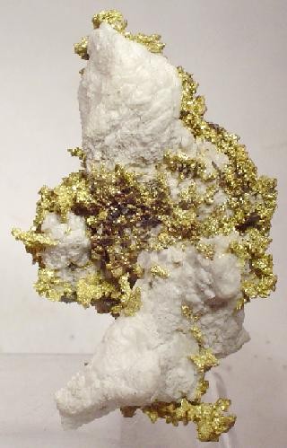
Gold mining prisoners in the Kolyma Basin.  They are mining placer gold that is found throughout the area.


The Gulag Ore Field or more correctly the Ducat gold/silver deposit that is located in the central part of the Balygychan-Sugoi trough that is a graben shaped depression that is located near the town of Omsukchan, Kolyma that adjoins to its north the Okhotsk – Chukota a marginal continental volcanic belt.

The deposits of gold are centered on a Cretaceous (ca. 120 million year old) volcanic dome consisting of ultra-potassic rhyolites, ignimbrites and tuff that are interlayered with black argillites.  The whole volcanic complex is intruded at depth by a late Cretaceous (ca. 85 million year old) granite that is from 1,200 – 1,300 meters below the surface.

More gold miners at work in the Kolyma Basin


There were pulses of igneous activity that caused hydrothermal activity to occur in the dome that involved large quantities of fractured, porous and highly permeable Cretaceous rhyolite sills and other steeply dipping subvolcanic bodies to be affected covering an area that covered more then 25 square kilometers.

Most of the known mineralization was later to the younger intrusion that includes tin bearing greisen-type that occurs in the contact zones of the granitic plutons. They ore deposits himself were located at a considerable distance from the granite.

Part of the Kolyma Basin is within the Arctic Circle giving it a sub-Arctic climate having very cold winters that can last for up to six months. Most of the area is covered with permafrost and tundra. During the winter temperatures range from -19°C to -38°C with even lower temperatures found in the interior. Besides gold there are also rich reserves of silver, 10, tungsten, mercury, antimony, coal, oil and peat. It has been estimated that the area contains in addition to gold 1.2 billion tons of oil and one point 5,000,000,000 m³ of gas.

This is the area whose mineral wealth was discovered by Yuri Bilibin in the 1920s that was quickly developed into the infamous Gulag prison camps by Stalin in the 1930s. There was also the area Bilibin used as the model for his theory of Metallogeny and Global Tectonics that has gained much traction sense of the world of geology.

Development began in 1932 and of Joseph Stalin the Kolyma Basin became the most notorious place for the Gulag labor camps. It has been estimated that over 1 million people died en route to the area or in the Kolyma’s between from 1932 until 1954. It was Kolyma’s reputation that caused Aleksandr Solzhenitsyn ferrite his famous book the Gulag Archipelago. In this book Solzhenitsyn came to characterize it as the “pole cold and cruelty.”

Gold and platinum were found in the Kolyma during the time when industrialization began in the USSR under Stalin’s First Five Year Plan in a period when the need for capital that would finance this economic development.  The Kolyma Basin gold was a perfect fit and development of the basin began in 1932 based on prisoner labor. 

In 1932 construction began on Kolyma Highway into the interior those that become known as the Road of Bones because of the number of people in Paris in its construction. This role eventually came to serve 80 different camps that were not have around the region of the uninhabited taiga. The first director of the Kolyma camps was Eduard Berzin who was the Cheka officer that was removed in 1937 and shot during the period of great purges of the USSR.

Far Eastern Russia geologically is North American plate that also includes Kamchatka Peninsula in northern Hokkaido Island of Japan. This being so it is probable that the gold deposits of this part of Siberia are closely related to those found in the Tintina gold belt of Alaska. It also indicates that most landmasses on Earth are really just one supercontinent with the sole exception being Antarctica.

Saturday, August 13, 2011

Gold Occurrences in Nova Scotia


Nova Scotia gold in quartz
Photo by Rob Lavinsky


A gold province is contained in the Meguma Terrane of Nova Scotia that has been worked since the mid-19th century. According to geologists that have studied the Meguma Terrane they have discovered over 300 gold occurrences are deposits found in the Cambro-Ordovician group of rocks found in southern Nova Scotia, Canada. This group of rocks consists of two formations that contain several classic examples of both turbidite and mesothermal veined gold deposits. The first formation is a lower sand dominated flysch that is billed as the Goldenville formation that has been subdivided into several mappable units that is leading to a better understanding of what stratigraphic constraints are imposed on gold mineralization. Detailed investigations of the stratigraphy are still ongoing in all the major gold producing areas. The gold deposits found in the Steve's Road-Beaverbank long with the Mt. Uniacke are the major gold producing formations in Nova Scotia having produced over 47,000,000 g of gold in the past.

In the gold producing areas the Meguma rocks display a variable deformation ranging from into upright gently to moderately double plunging folds having multiple cleavages. Gold in the Meguma is divided into three major groups: 1 hi-grade that averages up to 15 g per ton; 2 low-grade averaging from 0.5 to 4 g per ton and 3g per ton gold that is hosted in meta-sandstone. A combination of either two can also occur.

Most of the historical production of 47 million g has come from hi-grade deposits found less then 200 m from the surface. The majority of the gold has been produced from a variety of veins ranging from bedding concordant, to fissure and stockwork veins. The veins were emplaced by the migration of metamorphic fluids during the late Acadian Orogeny of the Devonian. The Meguma is a good example of

Most of the gold in the Meguma is found in two formations: the Halifax formation and the Goldenville formation where it occurs in quartz veins and is often associated with the mineral magnetite.

The erosion products of the Meguma are found in the coal measures of Nova Scotia where it might be found in conglomerate as fossilized placer deposits.  Coal measures can be found in a belt extending roughly from New Glasgow under the Gulf of St. Lawrence to Glace Bay on Cape Breton Island.  Conglomerate in this area deserves a close look.


Thursday, April 28, 2011

Gold Producing Metallogenic Provinces and Epochs (MPE)

There are many metallogenic provinces and epochs (MPE) that can be traced through the formations of various rocks including those particular places and times when gold was deposited. There are at least eight of these episodes that can be found in the Appalachian Mountains of southern Québec. These MPE's can range all the way from the Grenville orogeny that occurred around 1.2 million years ago, and can be traced to different types of orogenies and mineralization to the end of the Permian era. 

A map of selected worldwide ore deposits of metals.
By KVDP


The different MPE's can be directly related to specific orogeny like the Grenvillian or any other orogenic event that has happened in the history of the world. An MPE can be found anywhere on the face of the earth. That means you had better know the geological history of the area where you are prospecting, and remember that some orogenic events left more gold behind them than others.

MPE's are usually associated with a suture zone where one tectonic plate has collided with another. In the case of an oceanic plate colliding with the continental plate the oceanic plate is subducted beneath the continental plate, and about 20 km inside account metal plate there should be a line of granitic intrusions.

The subduction zone acts as a giant heat engine melting the material that has been dragged downward by subduction causing it to become heated to the point the material is melted.  The subducted material is also saturated with water that lowers the melting point of the material, and supplies the water that at depths of kilometers beneath the surface of the earth becomes super heated water that is capable of dissolving many minerals that when they reach the right environment through the action of the superheated hydrothermal fluid are deposited as ore.

A subduction zone.
By A.J. Stern


Searching around in the area that has been intruded one is apt to find gold in the aura of contact metamorphism that is associated with the granitic intrusions. In this case gold is often associated with scheelite, an ore of tungsten in the form of tungsten carbonate. This occurrence is often found where the granite has intruded through an older layer of carbonate rocks such as limestone or dolomite where it forms a skarn..

On the oceanic side of the subduction zone are found many metal sulfide deposits where this whole deposits are usually found in small amounts, but there can also be some really huge deposits of sulfide that are formed this way. These are the result of sulfide deposits that are laid down by black smokers found on spreading centers located on the bottom of the ocean. These deposits are laid down very much like plums in a pudding at the scattered across the bottom of the ocean.

A black smoker at a spreading center at the bottom of the ocean. NOAA


As these deposits are carried away from the spreading center by the action of more magma being injected they cover the ocean bottom with spots where they are eventually subducted beneath a continental plate where they are often reactivated to form secondary mineral deposits sometimes in quantities large enough to form ore deposits.

MPE's are where ore deposits are typically found, and in many cases are considered to be the primary source of mineralization, and they eventually break down to form detrital mineral deposits.