Total Pageviews

Showing posts with label Gold Rush. Show all posts

Wednesday, June 13, 2012

How to Build a Gold Rocker Box:


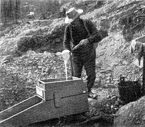
A gold rocker box in use


A gold rocker box is a device that efficiently recovers gold from river sand and gravel that is capable of processing more gold per hour then a gold pan.  Its invention was during the Georgia Gold Rush that predated the California Gold Rush by several years.  During the days of the Forty-Niners the rocker box was considered more important then the gold pan.  It was also important during the Klondike Goldrush because the miners were able to use the rocker box on higher stream banks because it used far less water then the conventional gold pan.

The Gold Rocker Box was a slightly more complex way of producing gold that could easily be built in the field by the average miner from rough sawn lumber.  It also had the advantage of being usable by one man.  It was built in two parts; the upper part was a box that acted as a grizzly separating the larger stones from the lower part where the smaller sand and gravel went to be processed. 

In essence the lower part was a sluice box from four to five feet long, and about a foot wide.  This part of the box was equipped with a set of cleats along the bottom of the sluice to catch the gold particles, and let the lighter load of gravel run out the lower end of the sluice box as waste.

The upper part of the gold rocker was a shallow wooden box with a one half inch screen that acted as a grizzly to remove the larger stones from the gravel that was passed through it on the way to the sluice box.  The miner discarded the larger stones, but first examined them to be sure he was not throwing out any gold nuggets.

A piece of canvas that went from the back of the upper box that was attached to the lower box assured that the gravel was properly dispersed into the sluice box.  This device has survived the test of time as the big dredges often used a rocker box to finish off the concentrate of gold and other stream heavies.

To build a rocker you start by building the upper box first this is about eighteen inches by twelve inches in size, and about four inches deep.  Then a lower sluice box is constructed that is from four to five feet long, a foot wide, and about four inches deep.  The upper box is attached to the lower box with four one x twos that are about a foot long.  A piece of canvas is attached to the rear of the upper box, and is angled down to the lower box and attached at the point where the upper box ends.  The lower box is equipped with a series of wooden cleats that catch the gold from the gravel that is being passed through. 

There is also some kind of a one x two attached to both of the boxes so that the miner is able to rock the device back in forth sideways while he is pouring water in through the upper box.  The whole device is elevated from the ground with a set of legs about four inches high that are attached to the sides of the lower box.  These legs are joined together by a wooden frame that is attached to the bottom of the legs.

In use the upper box is filled with gravel by the miner, then he pours water by the dipper full washing the gravel down into the lower box.  As he adds the water he rocks the whole device back and forth so the gravel falling through the grizzly is spread evenly in the lower box, and is thoroughly washed.  The gold, if any, collects behind
 the wooden cleats in the bottom of the lower box to be removed after a large quantity of gravel has passed through the device.  The larger stones that stay on top of the grizzly in the upper box are discarded, but examined first so you don’t throw away any gold nuggets.

The rocker box finds many uses in prospecting as it is able to separate any heavier material from lighter.  It is used for the panning of platinum group metals as well as the heavier gemstones like diamonds and sapphires.

References:


Thursday, November 10, 2011

Gold Occurrences in British Columbia

It is near Mt. Robeson where the Fraser River rises that was the scene of a gold rush in 1859.   Tobi87


It was in Yale, British Columbia on the banks of the Fraser River where I first learned about British Columbia gold there were several flour sized flakes gold in the bottom of my gold pan. From what I understand this flour sized gold is characteristic of the Fraser River. For the benefit of the reading audience it takes approximately 40,000 of these to weigh a troy ounce (31.1 g).  At the time there was a terrific thunder shower coming up, and I worked the pan out in about two minutes leaving the proprietor of the gold panning site completely mystified because he had already seen the Connecticut greenhorn could work so fast, he already seen the plates on my car.  He didn't know I had been a prospector most of my life. The Fraser River was the site of a gold rush in 1859, and there is still gold to be found in the Fraser River system.  There are also jade boulders found with the gold in the river.

Yale, British Columbia during the Freaser River Gold Rush in 1859


British Columbia also contains the southern terminus of the Tintina Gold Belt in the northern part of the province. This appears to be the largest gold belt in the world since it is traceable all the way from northern British Columbia, through the southwest corner of the Yukon Territory and sweeping all the way across Alaska for a distance of 1200 km where it finally ends in the Pacific Ocean just above Anchorage, Alaska.

The first discovery of gold by Whiteman was at Gold Harbor on the west coast of Moresby Island near the Haida village of Tasa in 1850 where it was discovered on Mitchell Inlet, an arm of Gold Harbor.  This discovery touched off a brief gold rush in 1851.  This led to the area being declared the Colony of the Queen Charlotte Islands.  The British government didn’t want the islands to be overrun by American Miners even though the gold deposits proved to be superficial in nature, and there are stories about the American miners being harassed by the local Haida warriors.  Later the area became the site of a modern mine for iron rather then gold.

Like all the beaches in the Pacific Northwest of the United States and Canada The beaches do contain flour gold in payable amounts sometimes covering the beaches with enough gold so they attract the locals trying to get as much of this gold as possible before the next tide washes it away until the next big storm that may wash up enough gold to be noticeable again.  In the same area the mountains of the coastal range including the British Columbia Batholith have had several producing gold mines and numerous showings of gold.

There is another gold producing area on the western slopes of the Rockies and the rivers and streams draining them.  This area was made famous during the Fraser River Gold Rush and the later Caribou Gold Rush. 

Gold is not the only source of mineral wealth in the province because it also contains world class deposits of jade that are mined both in-situ and as boulders of jade found in numerous rivers.  The area around Cache Creek has produced both gold and jade.  British Columbia is also noted for producing large quantities of copper, lead and silver.

British Columbia has vast deposits of mineral wealth throughout its length and breadth with many deposits yet to be discovered.  There are numerous mines that are accessible only by air especially in the northern part of the province.

Sunday, October 23, 2011

Discovery of Gold sparks mini Gold Rush in southeast United States

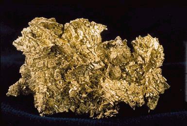
Crystalline gold   USGS


According to a report from Reuters recently a Canadian Mining Company along with a tiny town in South Carolina are leading the charge to what could become a modern gold rush in the southeastern United States.  The company from Canada is Romarco Minerals Inc. that has reopened the old gold mine at Kershaw, S.C. and by 2014 should be pouring its first gold bar.  The name of the mine is the Haile Mine.  The author originally became aware of this exploration project at the PDAC Show in Toronto in 2008.    

The Haile mine once environmental studies and the permitting process is completed will be the first modern gold mine is the Mississippi River since the Kennecott Minerals Mine that was in Ridgeway, South Carolina in 1999. Based on proven gold reserves that were found in the samples it is estimated that 3.1 million ounces of gold still remains in the ground at Haile. It is estimated this gold mine will produce an average of 150,000 ounces of gold for the next five years.

The slate belt that winds its way through the southern Appalachians from Maryland to Alabama was the site of the first gold rush in America before gold was discovered in California in 1848. It is interesting to note that this Slate belt north all the way to Quebec. Gold is been reported that sparked a gold rush in Columbia County and adjoining parts of Saratoga County, New York, and western Vermont in the northern extension of the slate belt. It's one of the most significant gold belts in the United States and sparked one of our first gold rushes in the early 1800s.

This is the first time that the southern gold belt has been explored using modern methods, an area that many people have forgotten how significant gold production was in the past. Most gold mines in the area were discovered by following placer deposits to their source. The glacier that destroyed the placer deposits in the northern United States and Canada has acted to prevent the discovery of gold deposits in the northern extension of the Slate belt.

Finding the gold left it daily has sparked renewed interest throughout the Slate belt in the southeastern United States. The gold found here is embedded in microscopic flecks in the volcanic rock in the so-called Carolina Slate Belt that extends from Alabama through northern Georgia, the Carolinas, Virginia and Maryland. In early October another Canadian mining company from Vancouver, Revolution Resources started investigating other old gold mines in the slate belt including the first mine, the Reed Mine in North Carolina.

During the period after the discovery of gold in North Carolina and the Civil War there were hundreds of gold mines scattered throughout the piedmont region of the southern states. Many of these gold mines were destroyed by the Union forces during the Civil War, others remained in production until 1942 when the federal government closed all the gold mines in the United States. There was even the working gold mine at the Great Falls of the Potomac River just upstream from Washington DC that was included in the shutdown of all the mines. Very few of these mines ever reopened and for the most part have been forgotten.

Tuesday, September 6, 2011

Gold Occurrences in Manitoba

Gold in Quartz.
Photo by Rob Lavinsky
There are several gold mining companies that are presently exploring for gold or mining it in Manitoba. The provinces also been the site of many gold rushes the earliest of which occurred in the southeast corner of the province where the abutts Ontario. This part of the province is part of the Canadian Shield as well as northern Manitoba where there are several operating gold mines.

The southern part of the province as well as the other Prairie Provinces is covered with a sequence of glacial lake sediments that are derived from glacial Lake Agassiz about 10,000 years old. Today, Lake Winnipeg is just a small part of Lake Agassiz. The gold deposits in the province are mostly found north of the Lake District where you encounter the ancient rocks of the Canadian Shield. It is these rocks that contain gold except for a narrow area in the far eastern part of the province. Gold and other valuable minerals are founded this area of the Canadian Shield.

The southern portions of these three provinces are the home to oil and natural gas; they also contain minable amounts of gypsum, potash and salt because they were covered by an ancient sea that bisected North America from the Gulf of Mexico to the Arctic Ocean. The Williston Basin extends into these provinces that also contain portions of the Bakken and Three Forks Formations.
Gold is found in northern Manitoba where rocks of the Canadian Shield are exposed. There is mining for gold and other metals in this part of the province. It isn’t only gold that they find. There are deposits of copper and nickel that are mined around the area around Flin Flon.
Manitoba is huge, it is almost as large as Texas so there is plenty of territory where you are able to prospect plus you have a provincial government that is quite friendly to the exploration and mining industries.
A good share of the exploration that is occurring in the province is between Rice Lake and Red Lake in Ontario. These two lakes are only 60 km apart and are both on the same continental fault. Although gold was discovered at Rice Lake in 1916 there were only a few mines that operated to the five hundred foot level. The deposits that have been discovered recently are all below the 1,000 feet.
Like a lot of other places in Canada it is often useful to prospect in the shadow of an existing mine. To find these old mines you are going to have to spend some time in the library researching them. Another good source of information about gold and other mineral localities is available from your provincial government.

Wednesday, August 24, 2011

Gold Occurrences in Ontario


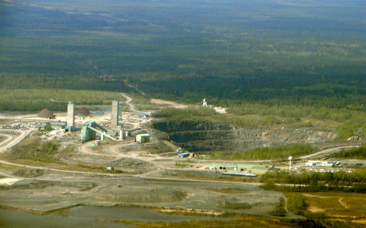
Kidd Creek Mine in Timmins Ontario   P199


The City of Timmins lies about 600 miles north of New York City it is common knowledge to most Americans that the Gold Rush happened in California in 1849, but a far larger gold rush occurred in Porcupine Ontario fifty years later.  Porcupine was later incorporated into the Township of Timmins, but Porcupine still exists complete with a Tim Horton’s shop.  One of the mines, the Dome Mine is still producing gold over a century later from a vast open-pit mine.  The other mines are now closed, but in West Timmins they have recently discovered one of the largest gold deposits of the past century.  It appears they haven’t written the last chapter in the book about Timmins Gold.

Most of the gold found in Ontario is found in the so-called Greenstone Belts the largest of which is the Abitibi reaching all the way from Wawa on Lake Superior into Quebec past Val D’or.  From this one Greenstone Belt there are more then 160,000,000 ounces of gold that have been mined since its discovery in 1909.  This is only one of several Greenstone Belts in the province that has produced gold. 

Gold bearing belts are found in several other localities in Northern Ontario with other notable occurrences at Cochrane, Red Lake, Hemlo, Marathon and so many other places that prospecting for gold in Ontario is practically the same thing as carrying coals to Newcastle. Many of the VMS mines in Ontario produce gold as a byproduct.  One example of this kind of deposit is found in the Kidd Creek Mine to the east of Timmins that was the site of a famous discovery in 1963.  Most of the gold that has been found in Ontario is from hard-rock deposits.

Somebody has said that there has never been a single nugget of placer gold that has been found in the province.  According to an open file report by the Ontario Geological Survey there appears to be a considerable amount of float gold present in the glacial drift of Ontario.  It is probable that placer deposits have not had enough time to develop since the glacier melted.  At any rate the report covers about two hundred pages listing all kinds of places where placer gold and indicator minerals for kimberlites have been found in Ontario.  You can access this document online by going here.

According to the author’s prospecting friends in Ontario all the prospecting done in the province is in hard rock. With the amount of gold that has been discovered that really makes sense. It could be possible that what has worked in the past will work in the future. The possibility of placer mining has not happened because of the scarcity of alluvial gold. Although the Abitibi region of Ontario holds many lode mines, placer deposits are practically non-existent. The glaciers of the past million years took the gold laden soil south and deposited it in states across the American mid-west. These are from New York to Illinois.
Most of the gold of Ontario is found associated with the greenstone belts of the Abitibi and Superior Provinces that span the whole province from Manitoba to Quebec. It is thought that the gold was mobilized from the greenstones that are metamorphosed basalts by hot water. It was deposited in quartz veins that are often found near fault systems.
Another place that gold is found in Ontario is in beds of ancient conglomerate. An example of this type is a large piece of conglomerate on display on the lawn of the library in Timmins. This is probably an ancient placer deposit that has been fossilized. The stones in this piece show little or no sign of having been metamorphosed. It is an example of an Archean sedimentary rock.
Some of the other regions of Ontario that have produced gold is the area around Wawa and Marathon. The Western part of the province is also promising country to prospect. Prospecting in Ontario is not just limited to looking for gold. There is at least one active diamond mine in the James Bay Lowlands, as well as diamond bearing kimberlites found in several places in the province.
Diamonds are often found in the same rivers and streams that carry gold in their sand and gravel deposits. The largest diamond that was ever found in North America was found in a placer deposit.
There are plenty of other minerals that can be found in Ontario as well. These minerals might not be as glamorous as searching for gold, but in many ways they are more important in the modern world. Among them are copper, lead, zinc, nickel, iron, lithium, beryllium, niobium, tantalum and the rare earth elements. The platinum group metals are often found associated with copper, cobalt and nickel.
If there is anyplace where people have looked in Ontario for mineral wealth they have found it. The province maintains a very active geological survey that holds vast amounts of knowledge concerning the mineral wealth of Ontario.

Thursday, May 26, 2011

Gold Occurrences in Colorado

The Argo Gold Mine and Mill in Colorado
Photo by Dustin Moore


Whatever you may say about gold it sure attracts people's attention in a hurry so it was with the Colorado Gold Rush. The gold miners were egged on by the cries of, “Pike’s Peak or bust.” Rumors of gold date back to 1807 when the Mountain Man Zebulon Pike heard rumors of gold in the South Platte River. By 1859 rich deposits of gold were discovered in the mountains west of Denver when the miners abandoned the plains. The first placer mines were around Denver sparking the first Goldrush in 1858.  Gold was found in the following plains counties Adams, Arapahoe, Douglas, Denver, Elbert  and Jefferson. Small amount of placer gold is still produced from Sand & Gravel banks around Denver as a byproduct of gravel washing operations by the aggregate producers.

The district around Central City and Blackhawk was another important gold mining district that produced enough gold to bankroll the modern city of Denver with several hardrock mines being in the district.  At one time the author had dibs on part of the Bates - Hunter mine in Blackhawk. This is officially called the Central City – Idaho Springs District. 

The Teller House in Central City Colorado. Central City was the site of several goldmines during the 19th Century.
Photo by Hustvedt


Gold was originally discovered in this area on January 5, 1859, by a former California prospector named George A. Johnson during the Pike's Peak gold rush. He made his discovery at Chicago Creek where it empties into Clear Creek; this marked the first significant Gold strike that was made in Colorado. Jackson who originally came from Missouri was able to conceal his strike for several months until he paid for some supplies with gold dust then the word was out. What had attracted Jackson in the first place were the large number of hot springs that belched columns of steam into the air. Jackson's discovery eventually led to a gold rush.

 The presence of hot springs in the area is an indication that hydrothermal water sent shed themselves of their gold content into the surrounding rocks. The same hot springs gave the settlement a new name that was to be known as Idaho Springs. On May 5, 1859 another miner named John Gregory discovered a gold bearing vein but was later called the Gregory Lode between Black Hawk and Central City that was called Gregory Gulch. Within two months of this discovery several other gold bearing veins were also unearthed. These discoveries gave rise to the establishment of other mining towns in the area including Nevadaville and Russell Gulch.

This is Pike's Peak that gave rise to the cries of Pike's Peak or Bust during the Colorado Gold Rush


For a few years hardrock mining prevailed in the district until the miners exhausted the free milling gold that was prevalent in the shallower parts of the deposits. This Friday of gold or worked fine for the amalgamation process, but the miners could not recover any gold once they reached the sulfide ore at a deeper depth.

It wasn't until the invention of an effective smelter for the sulfide ore by Nathaniel P. Hill in 1868. This was an achievement that allowed hard rock mining to continue in the district where several other smelters were also built. It is estimated that by 1959 this district produced about 6,300,000 troy ounces of gold mainly from sulfide veins that were found in gneiss and granodiorite.

The early miners made their discoveries at the northeast end of the Colorado Mineral Belt, but it wasn't too long before they started heading southwest across the mountains from Idaho Springs the miners traced the Colorado mineral belt west along Clear Creek, then over the mountain passes to South Park and from there to head waters of the Blue River.

This was the Breckenridge district where the miners first discovered gold in the 1880s, By following the placer gold to its sources at the miners discovered that were veins in the hills containing gold. The miners even recovered some placer gold from the gravel benches to the north of the Blue River. Although gold production Peter now during the late 1800s, but was revived by gold dredging in 1908 along the Blue River. During its lifetime the Breckenridge district produced about 1 million troy ounces of gold. Today the gold mines around Breckenridge are all closed, but there are a few that remain open for tourists.

As early as 1859 prospectors had already found rich placer deposits on the west side of South Park in the valleys on the east side of the Mosquito Range in the principle districts of Fairplay and Alma.  These deposits were located at the headwaters of the South Platte River with others in the Tarryall District alongside Tarryall Creek. Later they found lode gold deposits in the mountains above Alma.  Some of these deposits were worked with floating dredges until 1952.  These gold miners left behind them the gravel ridges seen today. It has been estimated that production from these operations recovered about 67,000 troy ounces of gold. Altogether the Alma-Fairplay district produced about 1.55 million troy ounces of gold with over two=thirds coming from lode deposits.

The discovery of placer gold at Oro City in 1860 opened the pages on the colorful history of the Leadville District.  The placer deposits were exhausted within four years, but the discovery of lode gold in 1868 that later lead to the discovery of large silver deposits in 1877.  It was also in 1877 that the city of Leadville was founded.

The gold and silver deposits at Leadville were deposited in a paleo-karst environment where the rich ores were deposited in ancient river valleys that were later covered by volcanic deposits. The ore here acted as a replacement of limestone that is a common association for gold.  The ore was in the form of lead/silver sulfides with gold being produced as a byproduct.  It has been estimated that there were about 3.2 million troy ounces of gold produced from the Leadville District.

In 1870 gold was discovered by prospectors along the Wrightman Fork of the Alamosa River and a year later they found lode gold in veins where full scale production commenced in 1875 once they had build a mill.  In this district gold production continued until 1906, but became sporadic after that until all production ceased in 1990.  There were about 520,000 troy ounces produced in the life of this district.

At the southwest end of the Colorado gold belt gold is found in Telluride District where the gold is associated with several Tertiary volcanic calderas including the remains of the largest eruption ever discovered “La Garita.” Here the deposits are found associated with intrusives in the older sedimentary rocks as well as chimneys and veins in the volcanic rocks themselves. It is estimated that this district has produced about 6.8 million troy ounces of gold while it was productive. The same district also produced sizable amounts of silver, lead and copper during the same period.

The Cripple Creek district has produced the most gold in Colorado was not discovered until 1891.  After the discovery the towns of Cripple Creek and Victor were settled to take care of the needs of the mines as well as the miners. Altogether this district has produced more then 21 million troy ounces of gold. 

The Cripple Creek and Victor Gold Mining Co. was formed in 1979 with the idea of starting gold production in the district by working mine tailings from the old mines. In the period when they were active from 1979 to 1986 they produced around 150,000 troy ounces of gold.

In an exclusive interview with Jim Burnell of the Colorado Geological survey it was revealed that there are several hard rock deposits of gold that are ramping-up to resume production.  There has also been a considerable amount of activity from the small scale miners that don’t have to report their findings to the state.  According to Mr. Burnell there have been several exploration companies that have expressed an interest in Colorado gold, but for proprietary reasons they don’t want to have their names revealed.

To a limited extent gold mining is still going on in a large scale in Colorado, but the difficulties in permitting a large scale mine today make it extremely difficult to open a new mine. Several mining companies have tried opening some of the older mines that are grandfathered.

Thursday, April 21, 2011

Gold Occurrences in Montana

Most of the Gold in Montana is found in the western half of the state where it was discovered in 1852 on Gold Creek in Powell County. Very rich deposits were found in 1863 in Creek near Virginia City created a gold rush. Since that discovery Montana has produced over 17,752,000 ounces of gold that is ranked as the seventh largest gold producing state in the United States. Most of the gold produced in Montana is a byproduct of the copper industry. Some of the best places to prospect for placer gold in Montana are located in Broadwater County on the eastern slopes of the Elkhorn Mountains in the rivers and streams that flow toward the east.

Elkhorn Mountain in Montana. Placer gold is found in the rivers draining the eastern slopes of the Elkhorn Mountains.
Photo by Fraser Harris

There is a great deal of information about mining for gold in Montana from the Bureau of Mines and Geology located at Montana Tech in Butte, Montana. The state is one of the signatories to the Mining act of 1872 that recognizes the right to file a claim on public lands belonging to either the state or federal government.

Western Montana is divided into two sections the Northwest and the Southwest in the northwest part of the state gold is found mainly in recent glacial moraines. During the early days when gold was selling for $20 per ounce of gold deposits found here were not considered to be economic although it was always possible to find gold. With today's prices the gold in these glacial moraines may become economically viable at $1500 per ounce.

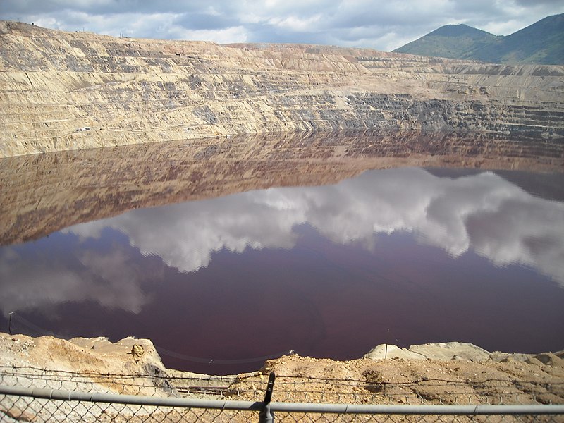
The Berkley Pit in Butte Montana an abandoned copper mine where gold was produced as a byproduct.
Photo by Cybergrl

Most of the gold in this thing however is found in the southwestern part of the state where many of the rocks are of Archean age is similar to those in the Abitibi region of Canada were mostly gold was laid down between 2.8 and 2.6 billion years ago.

Some of the greatest mines in the United States are located in western Montana there were copper mines many of them produced gold as a byproduct from refining copper. The greatest of these copper mines was the Anaconda Mine located near the city of Anaconda. This mine was discovered right after the Civil War by an Irish prospector that was looking for gold, and found copper instead.
The Anaconda mine was actually named because of a newspaper headline the Irishman saw while he was serving in the Union Army near the end of the Civil War. The headline read, “Grant encircles Richmond like a giant Anaconda.” Both the mine and the city were named after this giant snake found in the Amazon basin.

Gold is found throughout Western Montana wherever there are mountains. The best place to look for placer gold is in the rivers and streams draining those mountains. According to one source is doubtful that the old time prospectors ever found all the gold that is deposited there. There are now many prospecting tools that were unavailable to the early prospectors, one of the most useful of these is the metal detector.

The metal detector that is capable of detecting gold in hard rock or placer deposits. The best tool for finding gold is one that the old time prospectors were very familiar with it is the gold pan. To this day no one has ever devised a better the way of discovering gold deposits.

Aside from gold prospecting Montana also affords the prospector the chance to find sapphires along the Missouri River. There are many areas along this river that are open to fee prospecting. In addition there are several other localities in the state where you can find various gemstones for a fee.

Wednesday, January 19, 2011

Gold Occurrences in Alaska

Gold is found throughout Alaska, and the resources are as vast as the land itself. One of the prominent features found in Alaska is the Tintina Gold Province (TGP) an arching curve that extends all the way from northern British Columbia, the southwestern part of the Yukon Territory and crosses the entire state of Alaska where it finally vanishes into the sea northwest of Anchorage. This gold belt has produced several gold rushes over the years probably the most famous is the Klondike Gold Rush that occurred in the late 1890s.

A gold dredge working on the TGP
Photo by Chris Lot

The TGP covers roughly 150,000 km² that is bounded on the north by the Kaltag Tintina fault and on the south by the Farewell-Denali fault. Geologically it could be considered a suture zone where one tectonic plate collided with another one. Throughout most of this vast area you can only find a few roads one of which is the famous Alcan Highway that goes to Fairbanks. The apex of the TGP arc is just about centered on Fairbanks, Alaska. Altogether the TGP is one of largest gold provinces in the world at 1200 km long and about 200 km wide.

The Tintina Gold Belt superimposed on a Landsat image.   USGS

The regional climate that is associated with the TGP is generally subarctic that includes several different physiographic regions and ecoregions like that Yukon-Tanana upland, the Yukon River low lands and the Kuskokwin Mountains.

Geologically Alaska is made up of several different terranes with the Tintina gold belt being only one of many. Although the TGP is the largest one in Alaska gold can be found throughout the state. Most of the Gold that has been recovered in the TGP to date has been placer gold, but new methods of mining and metallurgy have allowed some previously known deposits to be brought online.

Virtually all of the known gold deposits in the state have already been staked, but it is still possible in the state of Alaska to buy or lease a claim. There is a lot of information about doing this on the Internet. We put into our web browser, “Mining claims for sale in Alaska” and had more than 9,600,000 hits.


In addition to the gold deposits found in the TGP that also contains many other deposits of Volcanogenic Massive Sulfide (VGM) minerals. Some of the other metals that are produced in the TGP include copper, lead, zinc and tungsten.