Total Pageviews

Showing posts with label Cameron's Line. Show all posts

Monday, July 30, 2012

Tales of the Devil to Date


The new entrance to Mine #1 The shaft is 40 feet deep with an adit going off from the bottom northweat for 10 feet that is 6 feet wide and 7 feet high.  The adit is well timbered and the shaft was filled with debris dating back to the 19th Century.
Photo by John Carter


We have rediscovered an old mining complex in western Connecticut that to date comprises two mine shafts with accompanying adits.  The first mine consists of a shaft approximately forty feet deep with an adit going off to the northwest that is ten feet long, six feet wide and sever feet high.  Town records reveal the first mine was a prospect hole that may have been created in pre-Revolutionary days; the second mine was just discovered on July 30, 2012 and is yet to be explored.  Town records indicate this mine may have an adit up to 140 feet long.

At the end of May 2012 a blue ribbon committee was convened at the site consisting of Charles Merguerian of Hofstra University, Nicholas Bellantoni of Uconn, Stefan Nicholescue of Yale, John Carter of Geotek and two engineers, none of us could determine what they were mining.  The town P&Z Officer finally discovered some old records that divulged the fact the second mine was dated to 1858.  The mineral mined was chalcocite an ore of copper.

The mines were found within two miles of Cameron’s Line a major fault system that extends from Staten Island, NY the western mountains of Norway under a series of different names.  There are several important mines located in the proximity of this suture zone producing gold, silver and copper.  The largest copper mine in the U.S. before the discovery of copper in the Keweenah Peninsula of Michigan was the Argo Mine in Vermont that is also associated with this large fault system.

The property where these mines are located is highly mineralized containing in addition to chalcocite, malachite, pyrites, quartz, kyanite, ilmenite, magnetite, cerrussite, beryl and many other minerals yet to be identified.  Although there are no plans to resume mining operations at these old mines mineral specimens will be available for sale.  For further information contact John Carter at geotekllc@gmail.com or 860-469-4804.

Many of the specimens of kyanite, ilmenite and magnetite are of museum quality and are really spectacular.  Some of these specimens are on display at the Yale Peabody Museum in New Haven, CT.

Tuesday, June 12, 2012

Tales of the Devil: Origin of the Rowe Schist

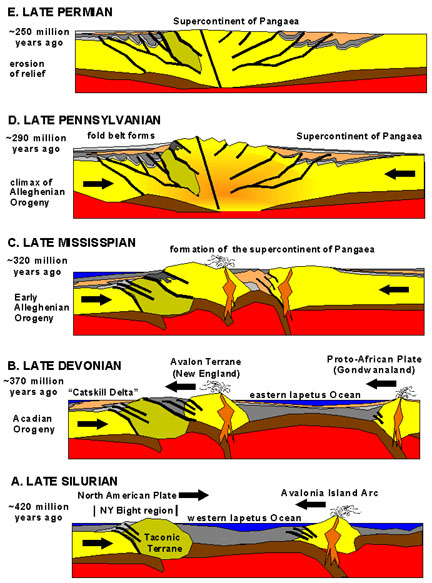
The earth movements that affected the Appalachian Mountains after the Taconic Orogeny   USGS

During the late Cambrian and early Ordovician a series of turbidite flows came down the continental slope of the North American craton.  This was the origin of the Roweschist formation.  Turbidites are also good sources of gold ore.  There are several examples of this kind of formation worldwide with the Witwatersrand of South Africa being the most notable.  Much of the gold ore from Timmins, ON is another example as are many of the deposits of the world.  To date the Witwatersrand has produced around 40% of the entire world’s gold supply in the past 40 years.  The gold mines found here are some of the deepest in the world that now are approaching 13,000 feet deep.

Earth movements associated with the Taconic Orogeny during the late Ordovician caused this layer of turbidite to be shoved to its present location close to the Iapetus Suture zone that locally in Connecticut and New York is called Cameron’s Line under differing names it reaches to the mountains of western Norway.  It is truly one of the largest suture zones on earth.  By definition a suture zone is also a subduction zone where rocks of oceanic origin are forced under the continental margin.  Cameron’s Line is about two miles west of the Rowe schist the formation that underlies the property belonging to the finder of the Whodunit Mine.

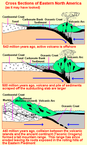
According to the USGS the following illustration graphically explains the Taconic Orogeny an Alpino type orogeny, a long narrow belt of mountains that formed the Taconic mountain range.  This is the orogeny that initiated the first of several mountain building events that occurred in the Northern Appalachians.  This is the orogeny that had the greatest effect on the Litchfield site.

The site itself is composed of a series of turbidite flows that flowed down the continental slope into a back arc basin behind the island arc.  This was composed of the sand and mud component illustrated in the first of the illustrations shown of the below diagram.  The Hoosac Schist on the landward side of Cameron’s line is represented by the portion marked sand.  The continental crust is represented by the Precambrian rock north and west of the site on the landward side of Cameron’s Line. 

Cameron’s Line is where the Hoosac schist and the portion marked sediment meet in a long suture line that extends from Staten Island, NY that was broken in half after the Atlantic Ocean opened during the Mesozoic and after passing through Ireland, Scotland eventually ends in the mountains of northern Norway.

When the Taconic Orogeny ended the mountains that rivaled the Himalayas in height were completely eroded away to a flat plain we know as a peneplain.  There were small mountain building events that occurred during the Silurian that although they affected the local area were so small as to be hardly noticed.  The next big event that affected the eastern seaboard occurred during the Devonian called the Acadian Orogeny.


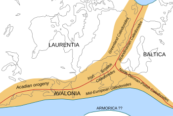
The Acadian Orogeny produced a different type of mountain range that was much broader then the Taconic Orogeny that to geologists is a Hercyanian type orogeny that was caused when Europe sideswiped the North American Continent.  It was during this event that the Rowe schist was intruded with molten magma causing it to become a type of rock called granofels.  This action caused many secondary minerals to be deposited in the schist ilmenite being the most prominent.  The event also caused further deformation to the Rowe schist.

At the end of this orogeny the Rowe schist has stayed above sea level unlike at the end of the Taconic orogeny as the rocks were eroded smooth the ocean came back to cover the land with ocean water.

Land affected by the Acadian Orogeny.  The original path of Cameron's Line is depicted in red. 


For the most part the only Orogenies that affected the local area were the Taconic, the Silurian (?) and the Devonian.  The later Orogenies affected the lands to the south and east.

Friday, August 26, 2011

Orogenic Gold Deposits


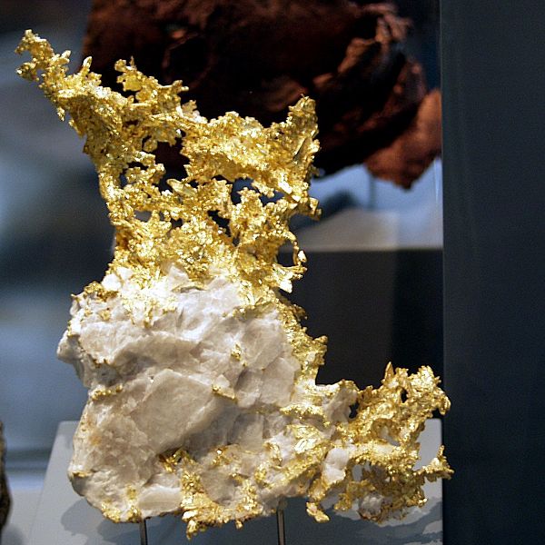
A typical specimen of orogenic gold from California
Photo by Raimond Spekking


Over the last century this class of gold deposit has been known by many different names like mesothermal gold deposits, metamorphic gold, gold-only, lode gold, shear-zone hosted, structurally controlled and a host of other names including greenstone-hosted and turbidite hosted deposits.  To cover this mélange of varying names the term “Orogenic Gold” has been proposed by (Grove et al) in 1998 to cover all these varying terms.  The reason for the change is to lower the confusion in terms since over the years they have changed causing a great deal of confusion in the scientific community,  The reason for this confusion is because of the nature of these gold deposits.  Many of these deposits are hosted in rocks that are intensely deformed and have been intruded from the effects of  regional metamorphism or intrusion by magma.

The Highlands of New York and Southern New England.  This is the type of terrane where gold might be expected.
Camerons Line runs through Connecticut to Staten Island NY.  The black on the map represents an ancient suture zone where rocks of continental origin are in contact with sedimentary rocks that were metamorshosed to schist during the Taconic Orogeny.   USGS
One of the important features of describing these gold deposits as orogenic gold deposits is because they can be found in any type of rock.  Deposits of this nature can be found in metamorphic terranes of various ages that display variable degrees of deformation.  The rocks that host gold deposits range from volcano-plutonic or clastic-greenschist facies commonly found in amphibolite or granulite.  Deposits of this nature can be found in areas that have undergone regional metamorphism or where the immediate area has undergone local contact metamorphism from the intrusion of hot magma.  Some of these deposits can be found in areas that at present represent areas of ancient major tectonic boundaries.  An example of this is found in the north-east part of North America in the fault contact between continental rocks and deep sea rocks that is represented by a fault system undergoing several name changes, but locally is called “Cameron’s Line.”  Most of these features are either compressional or transpressional tectonic settings.

You can find orogenic gold deposits in metamorphic terranes that display various degrees of deformation and various ages.  The rock hosts are various environments that include volcano-plutonic and sedimentary-clastic terranes.  The host rocks have usually been metamorphosed to greenschist facies.  In some places locally the metamorphism can be amphibolite or granulite.  Typically the gold deposits of this environment occur in regional crust scale environments.  They usually display a brittle to ductile style of deformation.  In many cases they are likely the present day expression of major ancient tectonic boundaries.  The gold deposits can be found in  any host rock.

These is a wide diversity of environments displayed that have strong structural controls in the gold deposits.  Orebodies are found in all sizes and all scales.  The morphology of these deposits is very variable including such diverse types as (1) brittle faults to ductile shear zones, (2) extensional fractures, stockworks and breccias and (3) fold hinges.  Many of these Orebodies are composed of highly altered host rocks that have disseminated mineralization of fissure filled deposits.  Many of these deposits can display a large vertical size exceeding 1 km in extent or more.