Total Pageviews

Showing posts with label minerals. Show all posts

Tuesday, July 10, 2012

Tales of the Devil: The Hammer of Thor


The new find on the site


Somebody asked me why we named this series, Tales of the Devil. Well back in 1819 one of the sources wrote in the American Journal of Science 1st Edition a paper about minerals found in Litchfield County.  Then he got religion and during the 1850’s wrote a tract called “Tales of the Devil.”  By then he must have been a full-fledged geologist from Yale.  At least he knew his subject matter.  However, “Tales of the Devil” fits this place as well as any other story, but finally some old records came to light that explained the whole place.

Since its rediscovery in March 2012 this site has had at least five PhDs tugging their forelocks trying to figure out what in blue blazes went on there.  Finally one of them found a collection of old records that explained the whole deal and even named some of the historical personages that were involved with the site including P.T. Barnum and Thomas Edison.

The first shaft and adit that was discovered was apparently a prospecting pit, or if you prefer a gopher hole. This consisted of the mineshaft that was 40 feet deep with an adit at its bottom going off that was 10 feet deep by 6 feet wide by 7 feet tall. It is apparent from the records that this may have existed since pre-Revolutionary War times. Most of the mining occurred in the mid-19th century and according to the records underground mining in the location included an adit that was more than 140 feet long.

Because of the geology on the site being similar to those where gold was found we assumed that was what they were looking for, and probably was. According to the old records covering the site what they were actually found was copper, and it was in the form of the copper sulfide mineral called chalcocite, a grey colored mineral.

Actually this tale doesn’t have anything to do with Thor except there’s a Norwegian involved in its telling. He was one of the PhD's.  Another one came from Transylvania.

Wednesday, February 16, 2011

The Role of Supercritical Water in Forming Gold Deposits

Supercritical water or hydrothermal water is found several kilometers below the earth's surface when the pressure of the overlaying rocks exceeds 220 times more than the atmospheric pressure at sea level as well as elevated temperatures up to 600°C. Water at this temperature is considered supercritical and does not behave like ordinary water; at this temperature water is capable of dissolving most minerals in the surrounding rock including gold.

You could liken supercritical water to water that has been heated in a pressure cooker except it reaches far higher temperatures and pressures than can be reached on your kitchen stove. At these extreme pressures and temperatures the water ceases to act like ordinary water instead it becomes far less dense than water and capable of going places where ordinary water can't go. At the same time it is also capable of carrying large amounts of dissolved minerals that are carried essentially upwards until they reach a place where the temperature or pressure has dropped enough to cause their precipitation. 

Another cause of this precipitation is if the mineral charged waters strike a type of rock such as limestone or quartzite that causes a reaction with the supercritical water causing certain minerals to fall out of solution. It is supercritical water that is the driving force behind metamorphism and all its processes.

Gold in Quartz from Jamestown District, Boulder County, Colorado
Photo by Rob Lavinsky

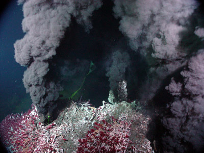
Generally supercritical water works with carbon dioxide and sulfur that also create large deposits of metallic sulfides that are termed Volcanogenic Massive Sulfides (VMS). In very deep water such as that found in the deeper parts of the ocean supercritical water can be exhausted into the open water where it precipitates large clouds of metallic sulfides in a feature that scientists call “Black Smokers

Most of the gold this precipitation by supercritical water is between 100° and 200°C that is about the temperature at which the metamorphic rock slate normally forms. The gold is often found in quartz veins that intrude the beds of Slate.

Another type of gold deposit that can occur as a result of being precipitated from supercritical water is the so-called Carlin type of ore deposit where the gold is disseminated through the rock in specs so tiny they can only be seen with an electron microscope and may consist of this little is one ion of gold.

A similar situation is found in quartzite that has been stained by supercritical water passing through the sandstone in leaving behind a whole suite of minerals that can very often not be seen to the naked eye. This is especially true if the quartzite shows any form of yellow or even better green staining.

Black Smoker with clouds of metal sulfides surrounded by supercritical water
NOAA
If you are finding classy looking quartzite without any staining at all you can be almost sure that it is barren of any mineralization including gold. One of the things you should examine further is any quartzite that has been stained yellow or green. This is especially true if the quartzite is in a contact deposit close to an igneous intrusion where often form a halo around the intrusion. This type of deposit is called a skarn that can contain all kinds of mineralization including gold.

Monday, December 13, 2010

How to use Google Earth as a Prospecting Tool

Google Earth is so new it that has not had much of a chance to be used as a prospecting tool, but it is just like flying around in an airplane only much less expensive. other forms of satellite imagery and  aerial photographs have been used for years for a prospecting for valuable mineral deposits. With Google Earth it is possible to see the lay of the land without ever going to the site, so you can plan a prospecting trip before you ever get there. What is especially good about the program is that you can see places where gold and other valuable minerals are apt to be hiding.

The first thing you notice about Google Earth is that all the photos are vertical just like those used in geological mapping. You can also change Google Earth images so they are displayed as oblique photographs; for many people not used to vertical photographs the oblique photographs are more natural,and are easier to understand.

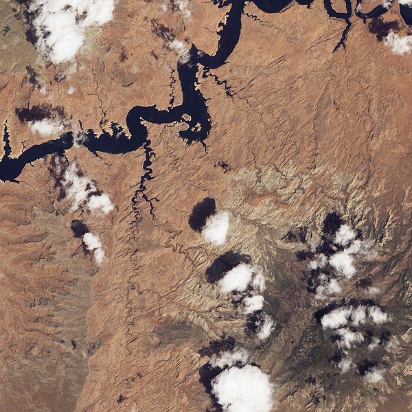
Natural Bridge area in Utah. Note the lineations depicted in this picture as well as the watercourses that are possible indications of a fault.

The next things you will notice if you look for are the number of lineations that can be seen in a Google Earth image. These are important because they often outlined a fault in the Earth's surface. Faults are often the home of valuable mineral deposits that have been deposited by hydrothermal activity.

Another place where Google Earth comes in handy is mapping the watercourses of streams and rivers. It should be remembered that streams and rivers often follow the line of least resistance this is usually a fault or contact between differing rock types. We can interpret these as zones of weakness that are apt to contain mineral deposits.

Another place where mineral deposits may be found is in areas with sudden changes in vegetation.  One example is most sand & gravel deposits are under growths of white pines.  In other places changes from deciduous trees might indicate an area is shallow to bedrock.  The presence of certain species of trees like oak that have a long taproot indicate the soil is deep and a long way from bedrock.  In deserts the presence of vegetation is often an indicator of water courses.

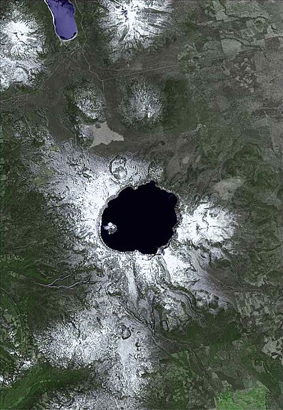
Satellite view of Crater Lake, Oregon USGS

Another feature that is readily seen on these images is the location of already existing mines. There is an old saying among Canadian prospectors that the best place to prospect for a mineral deposit is under the shadow of the head frame of an existing mine.

By looking at stream courses in a given area it is actually possible to pick up many of the places where placer deposits may exist in the inside bends of streams, or in former stream channels that are often visible on a satellite image.

Monteregian Hills, Quebec noted for rare minerals caused by magma intrusions from a traveling hotspot.

One of the neat things about Google Earth is a read out at the bottom of the display the geographic coordinates in degrees, minutes and seconds making it possible to transfer those readings to a GPS unit so you can find your way on the ground to areas you saw on Google Earth,