Total Pageviews

Tuesday, July 10, 2012

Tales of the Devil: The Hammer of Thor


The new find on the site


Somebody asked me why we named this series, Tales of the Devil. Well back in 1819 one of the sources wrote in the American Journal of Science 1st Edition a paper about minerals found in Litchfield County.  Then he got religion and during the 1850’s wrote a tract called “Tales of the Devil.”  By then he must have been a full-fledged geologist from Yale.  At least he knew his subject matter.  However, “Tales of the Devil” fits this place as well as any other story, but finally some old records came to light that explained the whole place.

Since its rediscovery in March 2012 this site has had at least five PhDs tugging their forelocks trying to figure out what in blue blazes went on there.  Finally one of them found a collection of old records that explained the whole deal and even named some of the historical personages that were involved with the site including P.T. Barnum and Thomas Edison.

The first shaft and adit that was discovered was apparently a prospecting pit, or if you prefer a gopher hole. This consisted of the mineshaft that was 40 feet deep with an adit at its bottom going off that was 10 feet deep by 6 feet wide by 7 feet tall. It is apparent from the records that this may have existed since pre-Revolutionary War times. Most of the mining occurred in the mid-19th century and according to the records underground mining in the location included an adit that was more than 140 feet long.

Because of the geology on the site being similar to those where gold was found we assumed that was what they were looking for, and probably was. According to the old records covering the site what they were actually found was copper, and it was in the form of the copper sulfide mineral called chalcocite, a grey colored mineral.

Actually this tale doesn’t have anything to do with Thor except there’s a Norwegian involved in its telling. He was one of the PhD's.  Another one came from Transylvania.

Monday, July 9, 2012

The Upside Down Mine


Sterling Hill Mine in Ogdensburg, New Jersey
Photo by Dmadeo


No, this isn't about a gold mine it's about a zinc mine specifically the one at Sterling Hill, New Jersey that for many years produced zinc and was one of the largest mines and the East Coast of the United States. The ore produced from this mine is noted worldwide for its many fluorescent minerals, but like all mines in eventually came to it in and was closed down although it still operates as a museum. At this mine and the ones in nearby Franklin, New Jersey form a canoe shaped orebody hosted in marble that is been the subject of much controversy over the years as to its origins.

During the 1960s Brian Skinner of Yale University was working for the USGS and with a colleague started speculating on how this ore body was emplaced. Under normal circumstances it is assumed that the ore came from deeper down in the bowels of the earth. However in this case under the marble was a layer of impervious rock that apparently did not allow the ore bearing hydrothermal fluids to rise up from below the marble.

Willemite, Franklinite and Rhodocrosite under Ultra-violet light from Sterling Hill
Photo by Rob Lavinsky


Skinner and his colleague were working in the mine one night when the question of the deposit’s origin came up.  The layer below the marble was impervious, but the marble itself wasn’t.  Many layers of sediments were deposited above the marble including some that were volcano-clastic in nature.  These rocks were also pervious allowing ground water to perk down from higher up that were capable of bearing ore bearing fluids.  They came to the conclusion that the ore bearing fluids came down from above and perked through the marble until they hit an impervious layer below the marble.  Here the ore bearing fluids stopped and gave up their load of dissolved minerals creating the deposit. However there is zinc minerals dispersed throughout the marble above the actual deposits.

This is all theoretical, but there are other examples of this same mechanism at work.  One glaring example can be found in the iron deposits found in northwestern Connecticut.  For almost two centuries the iron mines in Salisbury yielded some of the richest iron ore on earth that had its origin in the overlaying Walloomsac formation of schist interbedded   with marble.

The same specimen as above under normal light
Photo by Rob Lavinsky


The origin of this formation is volcano-clastics that came from an island arc that formed off the then east coast of North America that collided with the continent during the late Ordovician and caused the Taconic Orogeny.  This volcano-clastic material was the source of the iron that formed the famous Salisbury iron deposits, and supplied the magnesium that turned the limestone into dolomite.  The Walloomsac formation extends south from Lake Champlain to Manhattan where it underlies among other things the New York Stock Exchange.  Throughout its length at its base and in the underlying marble iron deposits are sprinkled like plums in a plum pudding.

It is theoretically possible that some gold deposits that are hosted by marble were deposited by the same mechanism i.e. leached from the overlying deposits.  A possible example of this mechanism in action are the gold deposits of the Carlin Trend in Nevada.  Another suspect is the San Pedro mine in San Luis Potasi, Mexico.  Both of these deposits are hosted in marble.  Keeping this mechanism in mind might lead to the discovery of other deposits of valuable metals.

Sunday, July 8, 2012

Streak Plates for Mineral Identification

Black and white streak plates showing colored streaks for pyrite and rhodocrosite on black & white streak plates

One of the most important tools in the arsenal used for mineral identification is the streak plate.  This aid to mineral identification is usually a piece of unglazed porcelain. The two colors most commonly used are black and white with white used for dark colored minerals, and black used for light colored minerals.

Black colored stones are often called touchstones for testing gold that leaves a golden colored streak that when treated with nitric acid can be used to tell the karat of the gold being tested.  If you draw a line with gold on a black piece of unglazed porcelain it leaves a golden streak that can be tested by applying different concentrations of nitric acid to the streak thereby finding its karat or quality.  24 karat gold is unaffected by the acid, but as the amount of gold in a sample decreases you are able to determine how much gold there actually is in the sample.  Different karat values have different colors.  For ages this was the definitive test for gold but it has been replaces by more accurate tests based on electronics.  In the test 24 karat gold is unaffected, but lesser grades of gold show increased chemical activity.

The black streak plate is used for testing for other precious metals belonging to the platinum group metals (PGM).  In most cases it is used to test light colored minerals.  Conversely the white colored streak plate is used for testing light colored minerals.

For our prospecting and mineral collector friends we have made available a streak testing kit composed of one each black and white 2”x 2” test plates for $10.95

Individual streak plates are available for $5.75 each.

They can be ordered online with instructions for their use included.

Full set black and white: $10.95 

Streak Plate Set (B and W)


Single black streak plate $5.75: 

Black Streak Plate


Single white streak plate $5.75: 

White Streak Plate


Connecticut residents please add 6.35% sales tax.

Shipping is included on all orders.

From time to time we will be adding other items useful for the mineral collector or prospector.

Photo by Ra'ike

Thursday, July 5, 2012

Gold Deposits in Ancient Turbidites

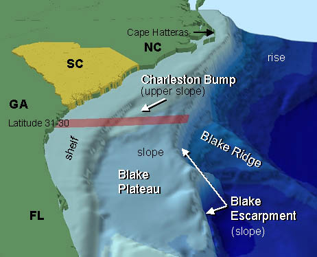
The southeastern coast of the United States - NOAA

The largest deposits of gold on Earth are found in ancient turbidites that include the Witwatersrand of South Africa and the Abitibi found in Canada in both Québec and Ontario. By definition a Turbidite is a landslide that occurs on a continental slope of a continental landmass where the erosion products of the continent eventually work their way to the abyssal plain at the bottom of the ocean that can be several kilometers deep.

Turbidites start at the edge of the continental shelf and can be caused by several different geological phenomena. They are deposited by a special type of water flow called a Turbidity Current that can be started by an earthquake, a powerful oceanic storm or in some cases just by the amount of material that collapses in on itself. The turbidity current contains not only water but suspended debris that causes it to flow out of town little slow but a speed that exceeds that of water itself because the current is also carrying suspended particles. Depending on the height of the slope the speed that it flows can reach as much as 70 km/h.

Once this flow reaches the bottom of the slope it quickly loses its forward speed and as it does drops off particles according to their density. It has such a high specific gravity of more than 19 gold is one of the first things that is dropped from a turbidity current. The finer particles and spread out over the abyssal plain of the ocean extending across the abyssal plain for hundreds of kilometers. In many cases at the edge of the flow the finer particles may only be a few millimeters thick, but over time this can actually be built into deposits of great thickness.

Mostly gold of the Turbidite deposit will say relatively close to the edge of the continent. Examples of these Turbidite flows are found in several places in the world one of the classic examples is the MegumaTerrane of Nova Scotia.

Some of the metals found in this environment include gold, silver, tungsten and antimony.  In western Connecticut the Rowe schist is an example of a metamorphosed turbidite.  This formation extends from northern Massachusetts almost to Long Island Sound in Connecticut.  Over the years reports of gold have been rumored about with this formation, but what is lacking is substantial proof i.e. no core drilling.

A capsule description of a turbidite deposit is gold-quartz veins, segregations, lodes, sheeted zones that are hosted by fractures, faults, openings in anticlines, synclines, along bedding planes in the turbidites and those that are associated with poorly sorted clastic sedimentary rocks.

These rocks are typically found close to the margins of continents or in back arc basins.  These rocks were typically deposited in submarine troughs, periarc basins, foreland basins and other remnant oceanic basins.  One feature that is typical of these rocks is multiple deformation events accompanied by metamorphism.  They show evidence of being thick sediment sequences displaying both deformation and are metamorphosed.  Although there can be some igneous rocks found in one of these deposits they tend to be quite rare and are usually present as pegmatites.  In some cases there are younger granitic intrusions associated with these rocks raising them to be raised to greenschist, but in some cases can reach amphibolite grade metamorphism.

The ore mineralogy of one of these deposits whether it is principle or subordinate includes native gold, pyrite, arsenopyrite, phyrottite, chalcopyrite, sphalerite, galena, molybdenite, bismuth, stilbite, bornite and other sulfosalt minerals. These minerals generally have a low sulfide content of less than 2.5%. The usual minerals found in association with these ore minerals are Quartz, carbonates, feldspar and chlorite.

When rocks of this type are discovered in glaciated terrains they may undergo deep weathering where alluvial recycling may produce rich placer deposits, such as in the Bendigo region of Australia.

There is several factors that control the ore deposits that are often found in fold crests, discordant veins and tension gashes. In some cases such as the in the Bendigo there is a relationship between ore deposits in the amount of graphite that is found in the country rock. The structural control is often extended to a district causing a scale alignment of deposits. Sometimes the veins appear confined to a specific stratigraphic interval that is often near to a change in stone type. Sometimes a more subtle relationship occurs lower deposits more closely related to the upper portion of the turbidite as of the magma district of Nova Scotia.

Because the low sulfide content, the majority of Quartz veins houses most geophysical methods of geophysical exploration to become ineffective it is often necessary to resort to the more usual prospecting techniques that are often accomplished with a gold pan by tracing the deposit.

In the deposit of this kind is not unusual to find deposits that range from a 50 g per tonne. Many of these are attractive targets for exploration as many of them are world class deposits.

Deposits of this type become incorporated into continental land masses with the death of an ocean by two continental masses colliding and the turbidite deposits are squished between the continents causing the turbidite to become incorporated into the mountain range that is a result of the collision. 

Tuesday, July 3, 2012

Gold Occurrences in Burkina Faso


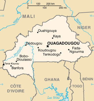
Map of Burkina Faso  -  CIA


In the past 40 years there has been a great deal of interest in gold mining in Burkina Faso. This is a country that is very geologically rich with the Poura region alone accounting for over 25 tonnes gold. As of 2003 the government brought about a new Mining act and immediately after there were more than 30 companies that have undertaken exploration projects in the country. They also created five new mines that are on the point of full production.

As demonstrated by the Abitibi region of Canada some of the richest gold mines in the world are located on greenstone belts.  In Burkina Faso greenstone belts cover about 3,000,000 km² of West Africa the Burkina Faso accounted for approximately 21% of these greenstone exposures. There are about 13 international mining companies that are active in this area now. .

As many as 13 international mining companies are working in the country mainly in the Greenstone belts. These belts account for over 21% of West Africa's Greenstone belt exposures that house on the world's most prolific gold mines. Some of these mines are capable of producing over 100 thousand ounces of gold per year. Much of this gold is produced by the heap leaching process and probably accounts to more than 1,000,000 ounces per year. Although some of these are producing mines, more of them are exploration projects that have been ongoing for some time.

All of the United Nations development program and Burkina Faso indicates that the early Proterozoic (Birrimian) Greenstone belts located at Boromo and Hound consists of steeply dipping volcanic and volcano-sedimentary units that have been intruded by the Eburnean granitoids there about 2 billion years old that have undergone incipient to low grade greenschist metamorphism. Many of the former gold prospects and mines are found in the Greenstone belts including the spell Poura vein gold deposit and the Dossi shear zone prospects. Much of gold that is discovered is associated with scheelite, calcium tungstate that is an ore for the metal tungsten.

Gold mining is one of the newest stories in Burkina Faso in recent years where the gold mining industry has been developing apparently inexhaustible resources.  There are many Australian companies that are already there searching for gold.  Many are finding it.

Most of the primary gold deposits are derived from metamorphic rocks that were developed from auriferous rocks that were eroded away long before the placer deposits bearing them were metamorphosed in the older volcanic and volcano=sedimentary rocks.  In this they are similar to the rocks found in the Witwatersrand district of South Africa and the Abitibi greenstone belts of Canada.

Sunday, June 24, 2012

Rock Hounding, or where you can go beyond Prospecting


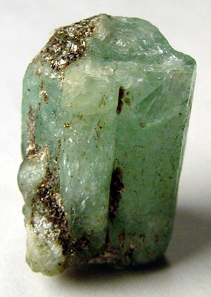
Uncut emerald one of the many members of the family of beryl minerals
Photo by Ryan Salisbury


Rock hounding is many faceted hobbies that make use of various earth materials as its objective.  Rock hounds can range in expertise from the rank amateur that collects pretty pebbles to world class experts on gemstones and minerals.  One of the branches of rock hounding is prospecting for gold and other precious metals.  There are many other fields of study that open to the rock hound as his level of knowledge increases.  Many rock hounds discover that over time rock hounding becomes a full time job.

One of the first things that have to be considered is the number of actual minerals there are, and of the latest count there were over 2000. Another thing that deserves a great deal of study is the number of minerals contained in each of the primary rack systems igneous, metamorphic and sedimentary. Each of these rocks systems contain some very specific minerals that are only found in one system. That being said has to be recognized that many mineral bridge more than one system. Probably one of the most outstanding examples of this is the occurrence of zircon they can be found in all three rock types.

Rhodocrosite from Argentina
Photo by Alberto Salguero


No doubt the most important thing most rockhounds want to learn is the identity of the different minerals they have found. This can be quite difficult considering the number of minerals that are recognized, but if you gold belt this systematically it becomes much simpler. All minerals have specific characteristics that are readily recognized that can take several forms. Many of these ways of recognizing minerals and trace their origin back to ancient times. The ancient Egyptians were quite adept at this practice and their knowledge of chemistry and mineral recognition was quite advanced.

There are a number of different ways of identifying a specific mineral among them are: hardness, color, specific gravity, transparency and fracture. One of the most accurate ways of identifying all minerals is by a process called x-ray diffraction spectrometry or what is commonly called a powder camera that is used by professional mineralogists. A powder camera admittedly is beyond the realm of rock hounds, but there are several tools that are still available to them.

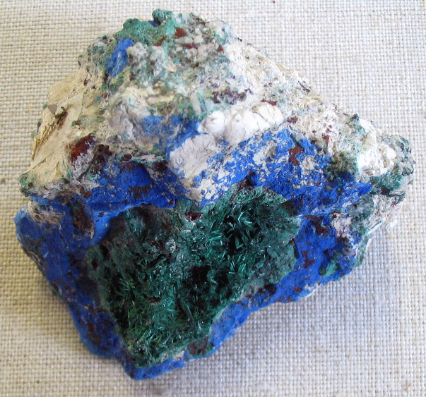
Azurite the blue mineral with malachite the green mineral from Russia
Photo by Aramgutang

The most common of these tools are the hardness testing kit that you can build yourself that are based on being able to scratch a sample. The hardness testing kit is based upon Moh’s Scale of Hardness that ranges from 1 to 10 with talc being the softest and diamond the hardest. Although you can purchase hardness testing kits you can easily make your own from readily available minerals. You can Google Moh's Hardness Scale on the Internet that will give you a list of the different minerals by hardness that are in the scale.

The next most important thing to consider is the mineral's specific gravity. The law of specific gravity was discovered by Archimedes in the city of Syracuse, Sicily during the days of the Romans. Each mineral is first weighed in the air and then weighed in water the difference between the two numbers is the specific gravity of the mineral. Once again a complete explanation of this can be found by Googling the phrase specific gravity.

Color and transparency are self-explanatory and most books on mineral identification are set up to show minerals by their color and chemical composition. Fracture is yet another important tool used in mineral identification.

Saturday, June 23, 2012

Tales of the Devil: Was it really a Gold Mine?


This is the end of the tunnel and with all the quartz veins exposed it sure makes you a believer, but subsequent tests failed to show any concentration of gold that exceeded the normal background level of gold.
Photo by Landowner


The question really arises is this thing actually a mine? The history of the area suggests that it may be something else; a tunnel excavated for the purpose of aging cheddar cheese. During the early 19th century the cheddar cheese production in the United States was in Goshen, Connecticut and spread out over several other towns in Western Connecticut. The most popular cheese that was produced was made in the shape of a pineapple that at the time was called pineapple cheese. This cheese whether it was made to look like a pineapple or simply cheddar cheese wheels. This cheese was so popular that it enjoyed a worldwide distribution being exported to the Caribbean, Europe and the Far East notably China.

The shaft and tunnel were recently rediscovered revealing a mine shaft that was about 40 feet deep with a tunnel going off from the bottom of the shaft that was 6 feet wide, 7 feet high and 10 feet deep. At the time of its discovery we all thought it was probably an abandoned mine but subsequent work that was performed on the mine with an x-ray fluorescence spectrometer (XRF) reveals no apparent minerals associated with gold or gold in this shaft and tunnel. So this left the question of what were they mining?

John Carter brought up the possibility that this was actually used for aging cheese. This hypothesis brought up one major objection from the landowner, and so far the other investigators are not aware of this possibility that what we thought was a mine was actually an underground tunnel used for aging cheddar cheese.

The major objection was the simple fact that this alleged mine was making quite a bit of water into the tunnel as well as part of the shaft. At first this seemed like a valid objection but further research reveals that they had hoses capable of carrying water clear back to 400 BC. Depending on the age of this feature it could have used hose made from leather that was secured by copper rivets, or a type of hose made from knitted linen fibers that were invented in the early 1800s. Either of these hoses was capable of being used as a siphon that would've kept the water in the tunnel under control.

In the early 1800s cheddar cheese was covered by a thin layer of cotton cloth then covered with lard causing the cheese to become waterproof. At the same time this covering of cotton cloth and lard allowed the gases that were being generated as the cheese aged to escape through the covering that kept the water from coming back into the cheese as it aged. However the cheese still had to be aged in a cool dry place which this was far from; it made water that was capable of filling the shaft about three quarters full. Without continually pumping the shaft and tunnel this complex was useless.

There was another kind of pump that have been used since ancient times called the Archimedes screw it used a helical screw turning inside a tight fitting to that was capable of raising water up to 10 m or close to 40 feet the depth of the shaft. It is possible they used a device like this for keeping the water out of the tunnel and shaft.

Had the complex been able to be used for aging cheese there would have been a series of shelves for storing the cheese, but once again these were missing so it has to be assumed that the whole complex was abandoned once the diggers were convinced it was useless for aging cheese.  The fact that further work was intended is attested to by a series of drill holes inside the tunnel.  Ultimately the vast amount of water entering the complex caused its abandonment.  This waterflow has been estimated to exceed twenty gallons per minute.  It would have been a pretty good well, but no place to store cheese.