Total Pageviews

Showing posts with label gold deposits. Show all posts

Thursday, July 5, 2012

Gold Deposits in Ancient Turbidites

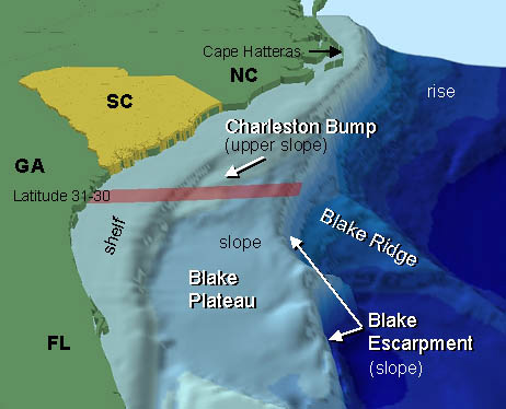
The southeastern coast of the United States - NOAA

The largest deposits of gold on Earth are found in ancient turbidites that include the Witwatersrand of South Africa and the Abitibi found in Canada in both Québec and Ontario. By definition a Turbidite is a landslide that occurs on a continental slope of a continental landmass where the erosion products of the continent eventually work their way to the abyssal plain at the bottom of the ocean that can be several kilometers deep.

Turbidites start at the edge of the continental shelf and can be caused by several different geological phenomena. They are deposited by a special type of water flow called a Turbidity Current that can be started by an earthquake, a powerful oceanic storm or in some cases just by the amount of material that collapses in on itself. The turbidity current contains not only water but suspended debris that causes it to flow out of town little slow but a speed that exceeds that of water itself because the current is also carrying suspended particles. Depending on the height of the slope the speed that it flows can reach as much as 70 km/h.

Once this flow reaches the bottom of the slope it quickly loses its forward speed and as it does drops off particles according to their density. It has such a high specific gravity of more than 19 gold is one of the first things that is dropped from a turbidity current. The finer particles and spread out over the abyssal plain of the ocean extending across the abyssal plain for hundreds of kilometers. In many cases at the edge of the flow the finer particles may only be a few millimeters thick, but over time this can actually be built into deposits of great thickness.

Mostly gold of the Turbidite deposit will say relatively close to the edge of the continent. Examples of these Turbidite flows are found in several places in the world one of the classic examples is the MegumaTerrane of Nova Scotia.

Some of the metals found in this environment include gold, silver, tungsten and antimony.  In western Connecticut the Rowe schist is an example of a metamorphosed turbidite.  This formation extends from northern Massachusetts almost to Long Island Sound in Connecticut.  Over the years reports of gold have been rumored about with this formation, but what is lacking is substantial proof i.e. no core drilling.

A capsule description of a turbidite deposit is gold-quartz veins, segregations, lodes, sheeted zones that are hosted by fractures, faults, openings in anticlines, synclines, along bedding planes in the turbidites and those that are associated with poorly sorted clastic sedimentary rocks.

These rocks are typically found close to the margins of continents or in back arc basins.  These rocks were typically deposited in submarine troughs, periarc basins, foreland basins and other remnant oceanic basins.  One feature that is typical of these rocks is multiple deformation events accompanied by metamorphism.  They show evidence of being thick sediment sequences displaying both deformation and are metamorphosed.  Although there can be some igneous rocks found in one of these deposits they tend to be quite rare and are usually present as pegmatites.  In some cases there are younger granitic intrusions associated with these rocks raising them to be raised to greenschist, but in some cases can reach amphibolite grade metamorphism.

The ore mineralogy of one of these deposits whether it is principle or subordinate includes native gold, pyrite, arsenopyrite, phyrottite, chalcopyrite, sphalerite, galena, molybdenite, bismuth, stilbite, bornite and other sulfosalt minerals. These minerals generally have a low sulfide content of less than 2.5%. The usual minerals found in association with these ore minerals are Quartz, carbonates, feldspar and chlorite.

When rocks of this type are discovered in glaciated terrains they may undergo deep weathering where alluvial recycling may produce rich placer deposits, such as in the Bendigo region of Australia.

There is several factors that control the ore deposits that are often found in fold crests, discordant veins and tension gashes. In some cases such as the in the Bendigo there is a relationship between ore deposits in the amount of graphite that is found in the country rock. The structural control is often extended to a district causing a scale alignment of deposits. Sometimes the veins appear confined to a specific stratigraphic interval that is often near to a change in stone type. Sometimes a more subtle relationship occurs lower deposits more closely related to the upper portion of the turbidite as of the magma district of Nova Scotia.

Because the low sulfide content, the majority of Quartz veins houses most geophysical methods of geophysical exploration to become ineffective it is often necessary to resort to the more usual prospecting techniques that are often accomplished with a gold pan by tracing the deposit.

In the deposit of this kind is not unusual to find deposits that range from a 50 g per tonne. Many of these are attractive targets for exploration as many of them are world class deposits.

Deposits of this type become incorporated into continental land masses with the death of an ocean by two continental masses colliding and the turbidite deposits are squished between the continents causing the turbidite to become incorporated into the mountain range that is a result of the collision. 

Tuesday, July 3, 2012

Gold Occurrences in Burkina Faso


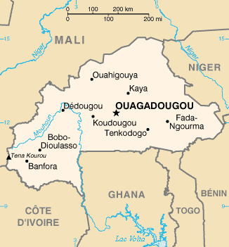
Map of Burkina Faso  -  CIA


In the past 40 years there has been a great deal of interest in gold mining in Burkina Faso. This is a country that is very geologically rich with the Poura region alone accounting for over 25 tonnes gold. As of 2003 the government brought about a new Mining act and immediately after there were more than 30 companies that have undertaken exploration projects in the country. They also created five new mines that are on the point of full production.

As demonstrated by the Abitibi region of Canada some of the richest gold mines in the world are located on greenstone belts.  In Burkina Faso greenstone belts cover about 3,000,000 km² of West Africa the Burkina Faso accounted for approximately 21% of these greenstone exposures. There are about 13 international mining companies that are active in this area now. .

As many as 13 international mining companies are working in the country mainly in the Greenstone belts. These belts account for over 21% of West Africa's Greenstone belt exposures that house on the world's most prolific gold mines. Some of these mines are capable of producing over 100 thousand ounces of gold per year. Much of this gold is produced by the heap leaching process and probably accounts to more than 1,000,000 ounces per year. Although some of these are producing mines, more of them are exploration projects that have been ongoing for some time.

All of the United Nations development program and Burkina Faso indicates that the early Proterozoic (Birrimian) Greenstone belts located at Boromo and Hound consists of steeply dipping volcanic and volcano-sedimentary units that have been intruded by the Eburnean granitoids there about 2 billion years old that have undergone incipient to low grade greenschist metamorphism. Many of the former gold prospects and mines are found in the Greenstone belts including the spell Poura vein gold deposit and the Dossi shear zone prospects. Much of gold that is discovered is associated with scheelite, calcium tungstate that is an ore for the metal tungsten.

Gold mining is one of the newest stories in Burkina Faso in recent years where the gold mining industry has been developing apparently inexhaustible resources.  There are many Australian companies that are already there searching for gold.  Many are finding it.

Most of the primary gold deposits are derived from metamorphic rocks that were developed from auriferous rocks that were eroded away long before the placer deposits bearing them were metamorphosed in the older volcanic and volcano=sedimentary rocks.  In this they are similar to the rocks found in the Witwatersrand district of South Africa and the Abitibi greenstone belts of Canada.

Friday, May 4, 2012

Gold Occurrences in Brazil


Coat of Arms of Brazil


Within its borders Brazil is the fifth largest country in the world; it touches upon all the countries in South America except Ecuador.  The country also has an astonishing variety of mineral deposits including iron, gold, gemstones, diamonds and oil.  There are literally hundreds of active mining companies found in Brazil.  Brazil also enjoys a rising economy and has a stable government with the future for mining being extremely bright.

The Amazonian shield covers much of the eastern portion of the South American continent and provides many of its gold mines.  Prospecting in the area is similar to prospecting in Canada’s Abitibi Gold Province in Ontario with a repeat of its greenstone belts with alternating gneiss’s.  There are also many deposits of turbidite hosted paleo-gold deposits similar to those found in the Witwatersrand in South Africa.  To the north of the Amazonian shield is the Guyana shield, to the south are the Rio Apa and Platian cratons and in the west is the Sao Francisco craton.  All of these areas are gold bearing.

Brazil covers 8.5 million square kilometers with 7,500 kilometers of coastline making it the largest country in South America, a size that dwarfs all its neighbors.  Its size is on continental size contains a vast resource base making it a prime target for attracting foreign investors and miners as well as Brazilian mining companies.  The country also has a long history of gold mining dating back into the 16th century.

It is estimated that less then 30% of the country has been adequately mapped so there is plenty of room for prospecting in both placer and lode gold deposits. Placer deposits can be found throughout Brazil except in the depths of the Amazon Basin, and there are plenty of gold deposits found in the Precambrian Shield areas that dot the country.

One of the biggest problems facing the Brazilian mining industry are the number of artisanal mining operations that keep popping up; there was a gold rush in the 1990s that centered on the Guyana shield that reportedly attracted over 90,000 miners to the area.  These miners for the most part disregarded good environmental practices resulting in large areas that were contaminated with mercury and other contaminants.

It has been found that artisanal mining is today the largest source of mercury release into the environment not only in Brazil but other countries too.  One of the sites mentioned that is the largest is in the Tapajos River Basin in the Amazon region of Brazil.  The Global Mercury Project (GMP) under the auspices of the United Nations is aiming to reduce this mercury contamination.

Brazil as a whole is mining friendly and enjoys a now stable government and a rapidly expanding economy that welcomes miners from around the world.  There are still vast amounts of the country that have not been explored, so one never knows what might be found just around the next bend of the river.

Monday, April 16, 2012

Metasomatic Gold Deposits


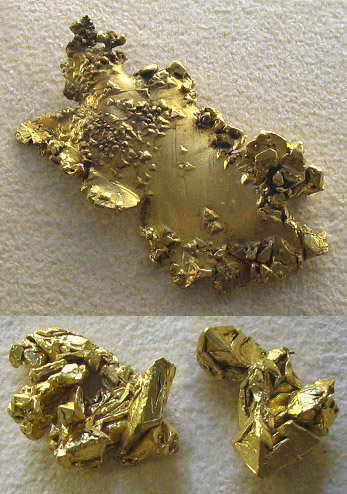
Gold Nuggets


Geologists consider Metasomatism as the chemical alteration of rock by hydrothermal or other fluids that can come from either an igneous or metamorphic source.  

If it was caused by the action of magma intrusions or volcanic activity Metasomatism makes skarns, greisens and may also affect hornefels if there is a contact metamorphic aureole next to the intrusive magma.  In a metamorphic environment it takes the mass transfer of liquid from a mass of hot rock that has water driven from it by the action of metamorphism with the water or other fluids acting as a solvent.

This occurs whenever rocks buried in the deep crust are losing fluids (dewatered) as well as dissolved mineral components because of the breakup of hydrous minerals.  The fluid with its dissolved minerals percolate to the near surface and in some circumstances reach the surface as springs of juvenile water.  The action of this hot water can chemically alter and change the crustal rocks.

It is this mechanism that tells us that metasomatism is an open system that is different from the usual metamorphic process causing an in situ mineralogical change in a rock, but does not alter the chemistry of the rock.  In effect metamorphism and metasomatism go to gather like hand and glove.

In practice metasomatism is in reality a mass transfer process that is best shown by gold ore deposits that are the result of the focused concentration of gold bearing metasomatic fluids.  These fluids drop their load of dissolved gold in shear zones and lodes.  Often the first indicators of gold are altered rock.  It is this mechanism that removes gold from greenstone and deposits it in adjoining rock.

This fluid is extracted from many cubic kilometers of rock where the overall content of gold can be quite sparse yet it is concentrated in the host rock.  One common example of this is the so-called saddle reef where gold is concentrated at the nose of a vertical fold where sometimes a large quantity of gold occurs in a small deposit.  Another type of deposit is illustrated by the Carlin Trend in Nevada where the action of metasomatism has caused the depositing of gold throughout a massive formation of limestone.

In order to be affected by metasomatism it is necessary for the rocks to be permeable to water.  Some of the other minerals formed by this mechanism beside gold are: copper, iron, molybdenum lead, zinc and tin.  Some of the industrial minerals formed are: graphite, mica, talc and wollastonite.

Because the fluids are moving through permeable rock one of the best places to look for gold is where one rock type contacts another.  That area acts as a dam for holding the mineral laden water in place where it deposits its mineral load. 

Thursday, April 5, 2012

Global Metallogeny and Gold Deposits


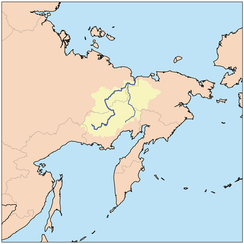
Map of the Kolyma Basin in the far east of Russia.
by Kmusser


The discovery of gold in the Kolyma Basin of the far Eastern Russia by the Soviet geologist Yuri Bilibin during the 1920s gave rise to a new science called Metallogeny and Global Tectonics. This gold producing area was later the subject of a book about the Soviet system of forced labor by Aleksandr Solzhenitsyn titled the Gulag Archipelago

In order to work three criteria have to be met, but in essence they say that mineral deposits can be found worldwide when these conditions are met.

1)      Mineral deposits are formed whenever energy is released at plate boundaries whether they are converging, diverging or transform plates.
2)      Plate tectonics are the controlling factor for the formation of mineral deposits.
3)      By reconstructing fragments of plates provide a useful tool in exploration for new mineral deposits.

In any tectonic setting for the production and accumulation of mineral deposits several requirements have to be fulfilled there has to be either a spreading center, a mountain building episode at a plate convergence or collision boundary, in craton rift centers, or cratonic basins.

The mid-Atlantic Ridge outlined by dotted lines.  This is a typical spreading center.


Deposits at Spreading Centers

In active spreading centers such as the mid-Atlantic Ridge or in the Red Sea where Africa is separating from Arabia are metallaiferous sediments on the flanks of the ridges that in many places are also marked by black smokers that contribute to the metal deposits.  Although these sediments primarily contain as sulfides iron, zinc, copper, lead, silver and gold; some deposits such as in the Red Sea containing iron, copper and zinc.

At some ridges important deposits of manganese oxide deposits are lain down.  This is especially important along the mid-Atlantic Ridge.

Another set of minerals found in ultramafic rocks that are called ophiolites are asbestos, chromite and nickel.  These minerals are found in Phanarozoic mountain belts where they are transported by tectonic movement.  The chromite is often found in Podiform deposits in ultramafic rocks most notably serpentines.  A different type of deposit of the same origin is massive sulfide deposits of iron and copper sulfides also associated with these ophiolite deposits.

A typical convergent plate margin aka a subduction zone.  


Deposits at Convergent Plate Margins

There are actually two types of convergent plate margins, one of them is where two continents are converging and the other is where two island arcs are converging metal deposits are commonly found at either type of plate margin.  The largest of these margins is the Circum Pacific Belt that contains major metallic deposits including over half the world’s production of copper.  All the metals can be found at convergent margins.

The zoning of mineral deposits in one of these zones is quite apparent with different zones being encountered the further you are away from the margin.  These varying deposits are liberated from the plate the further it descends beneath the mantle wedge with tin coming out of the slab at a depth of about 300 kilometers.  These metals come up with magmatic fluids and are concentrated in hydrothermal and magmatic fluids.  Epithermal deposits are commonly found in this regime.  Oil and gas are found associated with this type of convergent margin.  In some places hydrothermal fields are also found.


Collision Boundary Deposits
  
Collision boundary deposits are a wild mélange of differing types of mineral from a wildly differing variety of environments ranging from deposits associated with spreading centers to deposits found at plate margins.  Typical of these deposits are those found on the ocean floor that are spotted across the width of the plate that are subducted beneath the continental plate with the metal deposits being brought up into the margin by tectonic movements.  These ocean floor deposits are the primary deposits from which others are derived.

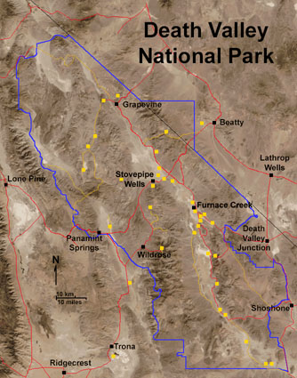
Death Vallet, California the yellow dots show the location of mines. This is a typical example of a cratonic rift system.
USGS


Cratonic Rift Systems

 Hot spots in the mantle of the earth cause a blister to form at the surface of the earth that causes three cracks to form on the surface two of them form an ocean and the third is called a failed arm of the sea or an aulacogen. A good example of this type of feature is the Ottawa Aulocogene in Canada.  Usually any granites emplaced during the early stages of this kind of development are rich in tin and fluorite.  Later in their development aulacogenes collect large accumulations of evaporates and other metallaiferous deposits.  In their late stages they are apt to develop deposits of fluorite, barite and carbonatites.  These can be characterized by deposits of niobium, phosphorus, rare earth elements (REE), uranium, thorium and in places tin bearing granites.  Geothermal fields also occur along rifts because of the upwelling of magma along the rifts. 

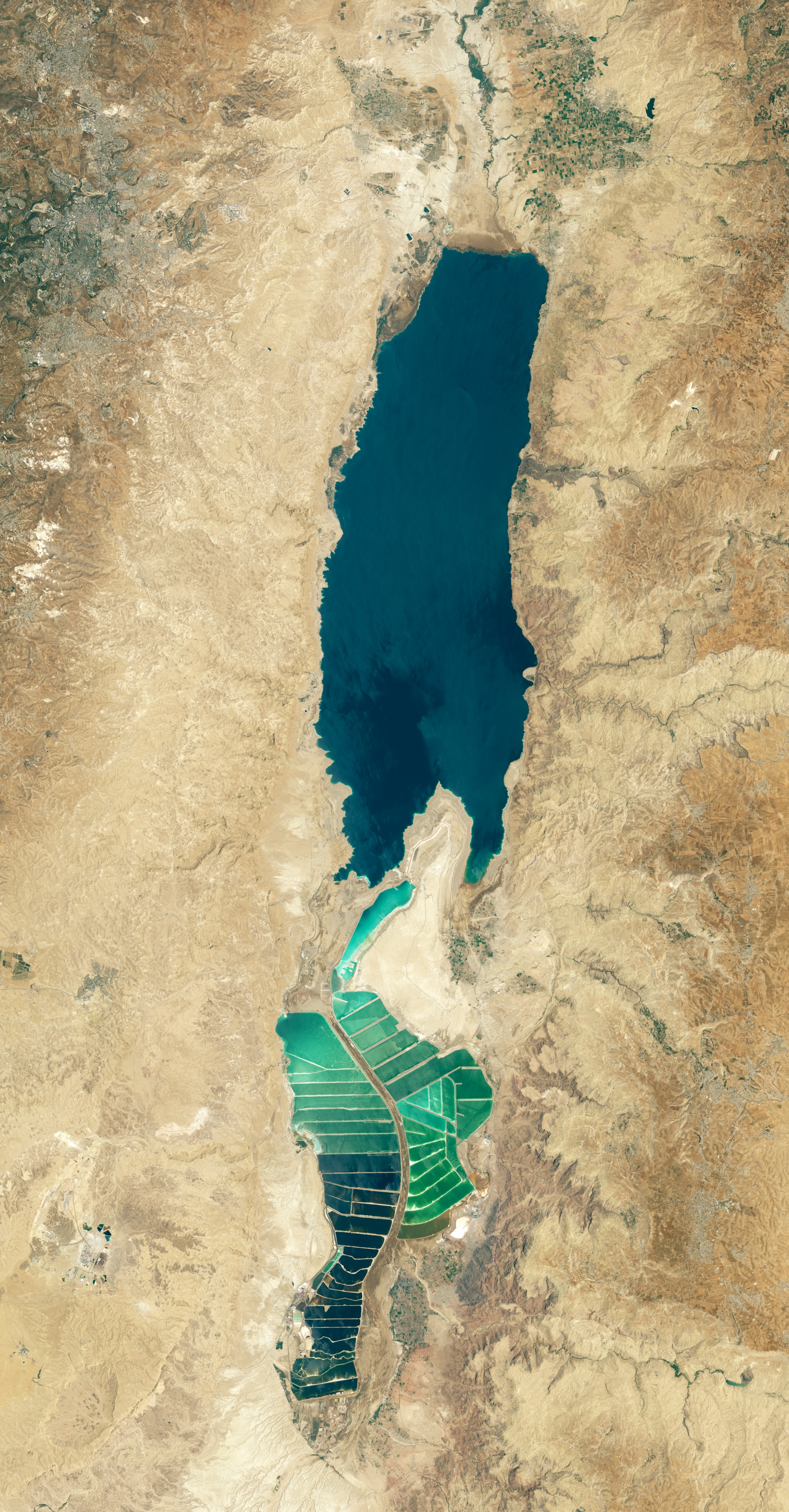
The Dead Sea from space.   NASA


Cratonic Basins

Cratonic basins are where the inflow of water from the sea causes an accumulation of organic debris from which petroleum products are derived.  The basin is also a place where evaporate deposits are laid down especially salt hence the association of salt and petroleum products.  The heat required for the transformation of organic matter is supplied by the burial of the debris under layers of sediment.  An example of a cratonic basin is Death Valley in eastern California.  One of the products of the ongoing evaporation is borax.  With continued rifting the basin usually becomes filled with water so that the circulation in the system goes from restricted to unrestricted with the depositation of organic matter ceases so does the depositation of evaporites.

Petroleum products aren’t the only thing deposited in cratonic basins like all the landforms described above gold and other metals are also deposited.  By understanding these features you have a pretty good idea of how metals are deposited so you can design an effective exploration plan.


Friday, August 26, 2011

Orogenic Gold Deposits


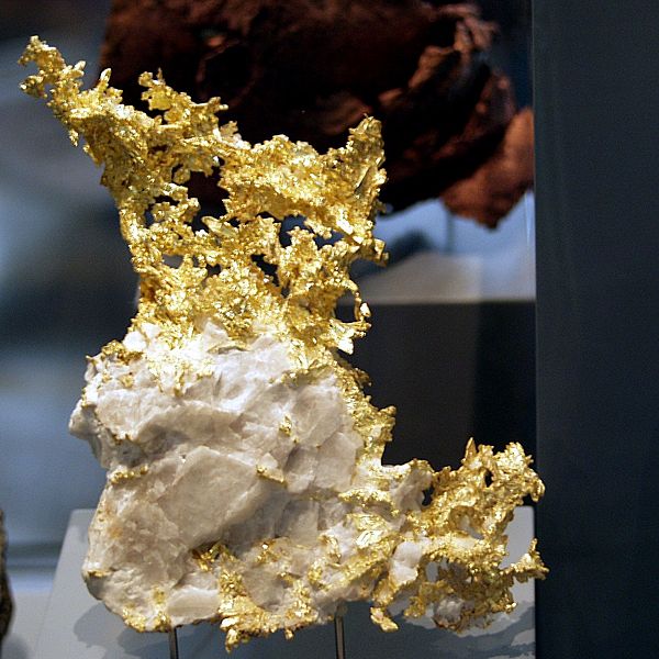
A typical specimen of orogenic gold from California
Photo by Raimond Spekking


Over the last century this class of gold deposit has been known by many different names like mesothermal gold deposits, metamorphic gold, gold-only, lode gold, shear-zone hosted, structurally controlled and a host of other names including greenstone-hosted and turbidite hosted deposits.  To cover this mélange of varying names the term “Orogenic Gold” has been proposed by (Grove et al) in 1998 to cover all these varying terms.  The reason for the change is to lower the confusion in terms since over the years they have changed causing a great deal of confusion in the scientific community,  The reason for this confusion is because of the nature of these gold deposits.  Many of these deposits are hosted in rocks that are intensely deformed and have been intruded from the effects of  regional metamorphism or intrusion by magma.

The Highlands of New York and Southern New England.  This is the type of terrane where gold might be expected.
Camerons Line runs through Connecticut to Staten Island NY.  The black on the map represents an ancient suture zone where rocks of continental origin are in contact with sedimentary rocks that were metamorshosed to schist during the Taconic Orogeny.   USGS
One of the important features of describing these gold deposits as orogenic gold deposits is because they can be found in any type of rock.  Deposits of this nature can be found in metamorphic terranes of various ages that display variable degrees of deformation.  The rocks that host gold deposits range from volcano-plutonic or clastic-greenschist facies commonly found in amphibolite or granulite.  Deposits of this nature can be found in areas that have undergone regional metamorphism or where the immediate area has undergone local contact metamorphism from the intrusion of hot magma.  Some of these deposits can be found in areas that at present represent areas of ancient major tectonic boundaries.  An example of this is found in the north-east part of North America in the fault contact between continental rocks and deep sea rocks that is represented by a fault system undergoing several name changes, but locally is called “Cameron’s Line.”  Most of these features are either compressional or transpressional tectonic settings.

You can find orogenic gold deposits in metamorphic terranes that display various degrees of deformation and various ages.  The rock hosts are various environments that include volcano-plutonic and sedimentary-clastic terranes.  The host rocks have usually been metamorphosed to greenschist facies.  In some places locally the metamorphism can be amphibolite or granulite.  Typically the gold deposits of this environment occur in regional crust scale environments.  They usually display a brittle to ductile style of deformation.  In many cases they are likely the present day expression of major ancient tectonic boundaries.  The gold deposits can be found in  any host rock.

These is a wide diversity of environments displayed that have strong structural controls in the gold deposits.  Orebodies are found in all sizes and all scales.  The morphology of these deposits is very variable including such diverse types as (1) brittle faults to ductile shear zones, (2) extensional fractures, stockworks and breccias and (3) fold hinges.  Many of these Orebodies are composed of highly altered host rocks that have disseminated mineralization of fissure filled deposits.  Many of these deposits can display a large vertical size exceeding 1 km in extent or more. 

Tuesday, July 19, 2011

Gold Occurrences in Tennessee

A piece of gold bearing copper ore from the mines at Ducktown Tennessee
Photo by Brian Stansberry


Most of the gold in Tennessee occurs in a narrow belt found in Monroe and Polk counties where they come into contact with the North Carolina border. For a distance of about fifty miles in the streams draining down from the Smoky Mountains placer gold deposits are formed.  According to reports placer gold has been discovered in the Caney Fork River around five miles below the Center Hill Dam.  Most of the gold recovered is found as small particles that are dust sized.  However, there are reports of larges sized nuggets as large as 2 or 3 ounces.

According to reports there have been a few nuggets recovered around Knoxville and further north in the area around Bristol, Tennessee.  Recent communications report that there is also gold found in the central Smokey Mountains to the northeast of Knoxville.  The author has seen some photographs of microscopic gold deposited in quartzite from this area.  Gold has also been recovered from the copper sulfide ores mined around the Ducktown area as a byproduct of copper and zinc mining.  

The bedrock map of Tennessee shows that the far eastern border of the state is in the Blue Hills province, a known gold producer that abuts the Valley and Ridge province immediately to the west.  The map indicates that the whole Smokey Mountain National Forest probably contains gold the problem is really one of the idea the place has never been properly prospected.

Bedrock Geological Map of Tennessee.  Most of the gold is found close to the North Carolina in the rock shown as brown. USGs


It was from the Valley and Ridge province where the author saw the photographs of gold in quartzite.  This is a perfect place to find gold as the quartzite and quartz pebble was eroded from mountains that were further east in the Piedmont province of North Carolina.  The Piedmont is peppered with gold mines, and it stands to reason some of this gold would have reached the Valley and Ridge province by the processes of erosion.

Gold has also been found at the Tellico plains as small grains eroded from bedrock of the nearby Unika Mountain on the border with North Carolina.  The Unika Mountains is where the gemstone Unikite is found.  This is a variety of granite with pink feldspar and green pisticite that is cut into cabochons.  The gold is found mixed with the soil from near the summit of the mountain in a stratum of soil that is from 10 to 12 inches deep.

Most of the Gold in Tennessee is found along the eastern edge of the state and rocks that are of Cambrian or pre-Cambrian age. Or also called on the western flank of the great Smoky Mountains as well as in the creeks a few miles east of not those Springs. Another place where it is found is in back of Chilhowee Mountain medicine bottle County. Gold is also found in Polk County on Citico Creek, Cane Creek, Coker Creek and the headwaters of Tellico River. Coker Creek in their own County produced nearly all the gold that has ever been found in Tennessee that according to some authorities about into a little less than $200,000 worth of gold.

Some of the best areas to prospect for gold in Tennessee are a narrow belt of stream gravels that are about 50 miles long in the southern part of Blount, Monroe and pull counties where they are alongside the North Carolina border. According to some authorities some of the best prospect in and be found in the rivers and creeks of Monroe County. Goals also found associated with the many copper mines of Polk County around the Copperhill-Ducktown Square is produced as a byproduct from the copper mines. 

Wednesday, June 8, 2011

Gold Occurrences in New Mexico

A copper mine in El Chino that produces gold as a byproduct.
Photo by Eric Guinther


New Mexico may be billed as the Land of Enchantment, but it is also known for its gold deposits as well as other minerals. These gold deposits generally follow along the crest of the Sangre di Cristo and other mountain ranges of the Rocky Mountains. This gold bearing belt cuts across the center of the state from the Colorado border south to the Mexican border. In this area it is possible to find both placer and lode gold. In much of this area gold is produced as a byproduct of mining other metals particularly copper.

Gold was originally discovered in New Mexico by the Spaniards in 1828, but there is evidence that the Native Americans they have found the gold deposits even earlier. This goal is mainly contained in a gold belt that cuts diagonally across the state from northeast to southwest that ranges from 50 to 100 miles wide. The gold and other metal deposits are closely associated with volcanic rocks found in the same area that can range from quartz monzonite to granodiorite intrusives. Most of these volcanics were produced during the Cretaceous or tertiery times.

There is a fine brochure produced by the New Mexico Bureau of mines and mineral resources that outlines the process of prospecting for gold for both amateur and professional prospectors. Many of the principles of prospecting can be used in other places as well as New Mexico.

There is no longer history of mining in New Mexico a place that had many good mines in the past, but today most of the gold produced in New Mexico is a byproduct of the copper mining industry.

The state also contains extensive placer deposits that have been washed down the mountains in dry washes and streams whenever a flash flood strikes. One authority states that the placer gold found that New Mexico has hardly been scratched because it is so dry that conventional panning methods don't work. To compound this does so-called dry panning methods don't work either because throughout the area the matrix containing the gold is damp and doesn't take kindly to conventional mining methods. Another factor limiting the hunt for placer gold is a layer of concrete subsoil called caliche but also limits the production of gold.

To find placer gold it is best to hunt in areas that have already produced gold. One of the places of interest is where deposits of gravel have come down from the mountains in arroyos, but these he posits are often naturally cemented together forming a stone like deposit that has to be treated like hard rock. Also the placer gold state is found between 3000 and 8000 feet. The higher elevations of least produce enough water for conventional placer mining.

Tuesday, May 3, 2011

Geosynclines and Gold Deposits

Geologic Provinces of the World.  USGS


A geosyncline is a long narrow trench that forms offshore from a continental margin that receives not only the sedimentation from the continental craton but other sources of sedimentation from deepsea sources.  Given enough time a geosyncline will develop into a subduction zone where the oceanic plate is subducted beneath the continental plate. In effect what this does is create a monstrous heat engine operating in the crust and mantle of the earth. In effect what a geosyncline is a giant heat engine several thousand kilometers long where oceanic crust is subducted beneath a continental plate. 

There are other geosynclines that can develop when two oceanic plats collide in this case it seems that the smaller plate is subducted beneath the larger plate.  The result however is almost the same as 20 to 30 kilometers away an arc of volcanic islands arises where many of the islands support a fine crop of andesitic volcanoes that erupts magma midway between basalt and rhyolite called andesite. Many of the volcanoes found in the Andes Mountains erupts this type of magma hence the word andesite the lava named after the Andes.

A late Cretaceous Subduction Zone on the west coast of the United States.  The geosyncline is the area depicted in white on the illustration.  Notice that some of this material is being subducted.  USGS


If this sounds like a geology lesson it is because this is all part of the Plate Tectonics theory that posits that there are about 20 tectonic plates of varying size that move across the face of the globe at speeds that measure in centimeters per year, or about as fast as a fingernail grows.  We live on and limit our mining to the crust of the earth that is roughly 10 kilometers thick.  Below the crust lies the mantle that proceeds down towards the center for a depth that is measured in hundreds of kilometers.  The mantle has about the consistency of tooth paste.  Below the mantle is the mesosphere that is more solid then the mantle due to far greater pressure.  The mesosphere is measured in thousands of kilometers.  At the bottom of the mesosphere is the core of the earth that is liquid descending ever downwards until you finally encounter the solid core of the earth.  Some geologists believe this is a single crystal of iron although there is really no way of proving this. 

Cross Section of the Earth   USGS


To introduce another concept is a measurement called the “Clarke” that is the average abundance of an element in the earth’s crust. The crustal abundance of gold averages 0.0000002 grams per ton from this number in order to achieve a commercial deposit, it is necessary to mobilize this gold where it is concentrated in some sort of trap where the gold makes a viable deposit; this is one of the many functions of a geosyncline.

As the material being subducted into the earth’s mantle it becomes superheated including the water that is riding on the plate that is being subducted into the lower crust and mantle.  This also includes any of the mineral deposits that dot the oceanic crust like polka-dots that are the from black smokers. It also includes the minerals that exist in solution in the salt brine that saturates the ocean floor.

Once all of this mixture reaches a sufficient depth the process of dewatering causes the water to boil, and at enough depth and pressure this water becomes supercritical, and also contains a witch's brew of chemicals that cause it to become highly corrosive and capable of dissolving just about anything that comes in contact with. The corrosive components of this water include chlorine, carbon dioxide and sulfur. Another function it serves is to lower the melting point of rock. By stripping the lighter elements from the rock it produces granite that works its way up through the crust of the earth in a manner that is very similar to what you observe in a “lava lamp.”

Gold is also mobilized by the same process and is carried through the surface of the earth where it is deposited as epithermal deposits in the roof rock over the granite intrusion, or in a contact metamorphic aura around the volcanic neck. This is the primary source of gold from which all other deposits of the metal are derived. It is also the primary source of practically all the other mineral deposits on earth.

Friday, April 22, 2011

Gold Occurrences in Idaho

According to the latest news about gold mining in Idaho, Premium Exploration Inc. (CVE:PEM) have focused their efforts on emerging gold district in Idaho in an area known as the Idaho Gold Project this is a district sized property that is seen over 13,000 m of recent drilling. This area is found in the Orogrande shear zone is a significant regional structure and also the conduit for multiple zones of gold mineralization. In many respects it is similar to the gold deposits found in the Carlin trend of Nevada. At present the Idaho Gold Project is 100% owned by Premium. At the present time Premium is working on an updated resource estimate along with a comprehensive 25,000 m drilling program.


A Yankee Fork Stamp Mill used to process gold and silver ore at the Custer Mine in Idaho.
Photo by Tinosa


The so-called Idaho Gold Project is located in Central Idaho as an epithermal deposit in the Cretaceous Idaho batholith and Precambrian basement rock where it is the conduit for alteration and extensive mineralization. It is also gone through several intrusions of rhyolite, dacite and trachyte during the Eocene. 

There was a considerable amount of placer and lode gold in the area from the 1860s until the 1930s. During that time it produced over 8,000,000 ounces of gold, and had over 20 historic mines. It wasn't until the 1970s however before modern mining and exploration techniques occurred within the area.

In 1940 report was good to go on their Idaho, C.A. Bottlfsen that was titled, “Mining Activity on the North Fork of the Clearwater River Area.” This report generated a considerable amount of interest in the area of the Clearwater River as well as Clearwater and adjoining counties in Idaho. This area is drained by the gold bearing Clearwater River and its tributaries.


The Argo Gold Mine and Mill in Idaho Springs.


The gold prospecting in Idaho usually lasts from roughly April 1 to November 1, clever if there's an open winter the prospecting season can be extended. The availability of water to carry on prospecting activities often dwindles after mid-June unless the prospector carries water to the prospecting site.

It isn't for nothing that Idaho was called the Gem State because it is the producer of many gemstones as well as gold and silver. Up to this point most of the gold that has been produced in Idaho comes from the upper part of the panhandle where it is found that placer deposits containing many gold nuggets.  The town of Murray is one of the best places to prospect, and because nuggets are so common you should come with a metal detector.

There was a time of Murray on a hotel owner wanted to go prospecting, but decided it was too cold outside. His solution was to cut a hole in one of the bedroom floors where he then go down 30 feet to bedrock to get at The gold. Another mine in the area of Murray was named the Jackass Mine that was literally found by a miner’s donkey. This is the kind of mining lore you can expect to hear in Idaho.


Two of the areas where you’re most likely to find gold are at the forks of the Pend Oreille River However, the hottest spot in the state is Boise County that has produced over 3 million troy ounces of gold from the 300 square miles of gravel that is found in the county. It would be a good idea to check out all watercourses and gravel arroyos to the northeast of Boise and close to Idaho City.


It is interesting to find the area around Boise is in a geothermal area that supplies the city with a large quantity of geothermal heat. The same area is also a place where gold is being actively deposited in areas where the geothermal liquids dropped below 200°C. It is common to find nodules of silica when you are digging within the area that in many places appears to be waterlogged. There are also known to be diamond bearing kimberlites in the same area, so you have your choice between gold and diamonds.


Boise County is not the only place where you can find gold in Idaho. The following counties are also listed for placer gold mining: Ada, Adams, Bingham, Blaine, Bonneville, Camas, Clearwater, Custer, Elmore, Idaho, Kootenai, Letah, Lemhi, Nez Perce, Owyhee, Power, Shoshone and Valley. It would be a good idea to check the watercourses and gravel arroyos found in these counties.
Aside from the gold that is found along the Clearwater River and its tributaries this river also produces star garnets that produce a star effect when cut en cabochon. The only other place where garnets like this are found is some locality in India. Jasper is found here also with at least one of the mines open to the public is the jasper mine at Willow Creek.

Idaho produces large quantities of precious opal of both faceting and cabochon grade. that displays a considerable play of color. One largest opal mines in the United States is located in northeastern Idaho called the Spencer Opal mine it is largest in the state.

Information about these mineral deposits in Idaho is available from different state and federal agencies. Sometimes you can find local history books to discover what kind of minerals were mined in a particular town.

The type of mining that went on in Idaho makes the use of a metal detector practically a necessity. Different manufacturers actually produce metal detecting instruments that are capable of detecting gold. Many of the gold nuggets that have been found are actually the result of metal detectors. A particularly good area to investigate is old mine tailings from dredge operations like the one in Boise County

We recently became a dealer for the Garrett line of metal detectors and other gold mining equipment including gold pans and gold panning kits.  Please watch for future announcements about the Garrett line of products.

Saturday, March 5, 2011

Epithermal Gold Deposits

Epithermal gold deposits are typically found in a near surface environment where the gold and other metals are deposited usually within 1.5 km from the surface. This type of deposit is always associated with volcanism either of the surface of the earth or in spreading centers at the bottom of the sea where their physical manifestation is hot springs, or are found associated with black smokers. They are commonly found in the vicinity of volcanoes either presently active or extinct where they form a halo around the point of eruption.

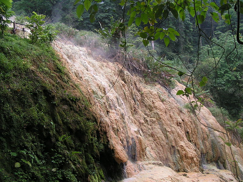
This is the type of mineral deposits that can be laid down by a hot spring.

An area where a epithermal deposits are common and is in the caldera of Yellowstone National Park where various mineral deposits are being deposited to this day due to the action of geysers, hot Springs and other geothermal events. This can be observed in the deposits of sinter that builds up around the geysers and hot springs. Yellowstone park itself is in a giant caldera that was caused by an eruption that occurred about 640,000 years ago. The hot spring activity that is associated with the park is caused from a magma chamber that is relatively close to the surface.

A prospector I know is working in volcanic terrain where the last eruption was 3 million years ago where the erosion rate is ~1 mm/year indicating that about 3 km of rock has eroded from the site since it had its last eruption.  In this terrain that is located within an ancient caldera enough of the surface rock has eroded away so that most if not all the epithermal deposits that were present, but around the periphery of the caldera one is more apt to discover epithermal deposits of gold and other metals then inside the caldera itself.

This is gold deposited on barite a common association in epithermal deposits.
Photo by Rob Lavinsky

This does not mean that gold deposits can’t be present in such an environment it just means that they are not likely to be epithermal deposits.  Although epithermal deposits are precluded by the depth of erosion it does not preclude other types of other hydrothermal deposits. Since epithermal deposits occur within a low-temperature environment that occurs less than 1.5 km below the surface it stands to reason that if there are still hot springs in this caldera it is still possible to have epithermal deposits occurring as secondary deposits superimposed on other deposits of hydrothermal origin.

Epithermal deposits occur in three different phases depending upon how much sulfur is present in the epithermal water. Deposits of this nature are classified as high sulfidation, intermediate sulfidation and low sulfidation each of these types of deposits are identified by their alteration mineral assemblages, occurrence, texture and in some cases are even identified by the associated element. Pyrite is the most common of these minerals, but you can also find mercury, antimony, arsenic and tellurium. Included in this suite it is also possible to find the base metals copper, lead and zinc as well as gold and silver. Gold and silver may be alloyed together as the alloy electrum. 

Friday, February 25, 2011

Prospecting on an Ancient Spreading Center

A tectonic ridge is associated with a spreading center where magma from the bowels of the Earth reaches the surface where it is the driving force for plate tectonics. The same feature is also the home of black and white smokers the source of many mineral deposits. For the most part tectonic ridges are found in the ocean deeps usually a depth of about 12,000 feet, but an exception is made for Iceland where the tectonic ridge is exposed on the surface of the land. Iceland is also one of the most volcanic areas on earth with the exception of the Ring of Fire that encircles the Pacific Ocean, but that is caused by just the opposite environment where tectonic plates are plunging beneath other plates in subduction zones.

Black smokers emitting clouds of metal sulfides.

The smokers are the result of ocean water penetrating deep into the oceanic crust that is composed of basalt, and leaching out the various metal ions and expelling the from the surface and clouds of metal sulfides. These sulfides are deposited in a particular sequence depending upon their solubility in water copper and iron are usually the first sulfides that are deposits and the other metals are deposited according to the  solubility of their sulfides.

Kidd Creek Mine in Timmins, Ontario

Although deposits of this nature are formed in the depths of the ocean is theorized that because of plate movement these deposits can eventually be incorporated into continental plates. A good example of this type of deposits is the Kidd Creek Mine located in Timmins, Ontario or the Horne Mine in Rouyn-Noranda, Quebec.

Monday, February 21, 2011

The Association of Gold and Magnetite

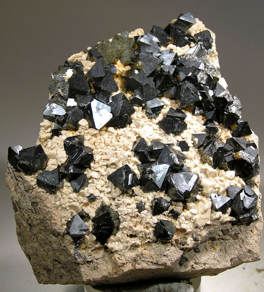
One common type of gold deposit is one where the gold is associated with the mineral magnetite where the gold is formed in skarns of granular magnetite.  The mineral has a chemical formula Fe3O4 that is often found in contact metamorphosed areas associated with intrusions of magma into carbonate or silico-carbonate rocks the intrusion itself is usually granite or monzonite-syenite. In such deposits the common minerals that are found include pyroxenes, amphiboles, garnet and lesser amounts of scapolite, vesuvianite and other silicates, but the most important is magnetite. 

Chalcopyrite deposited on magnetite.  The magnetite is the black crystals.
Photo by Rob Lavinsky

In the field magnetite is one of the most easily found of all minerals because it is magnetic and is attracted to a magnet; some of this mineral possess weak magnetism itself, so it is called lodestone.  The ancients were aware of this, and used it to make the first primitive compasses from magnetite carvings many of which looked like spoons whose handle pointed north. 

To prospector the first Association of gold and magnetite occurs in the bottom of your cold pan in the form of black sand that contains small specks of gold. This black sand along with other heavy minerals is considered to be ore in its own right, and is often refined away from streamside to recover its gold content.

Magnetite crystals in a matrix of feldspar.
Photo by Rob Lavinsky

Gold bearing magnetite may be found in massive deposits where the gold is often invisible to the naked eye with the gold often being disseminated throughout the entire deposit of magnetite. The lower bodies in this type of deposit can be presented as one in particular, tubular or more rarely as sheet deposits.

The sulfide minerals found in such a deposit are usually secondary in nature that have been deposited by mineral laden hydrothermal waters. In some deposits of this type goals is also associated with the sulfides, particularly arseno-pyrite as well as other sulfide minerals.

If gold is present in one of these deposits it is not to be disseminated through the body of the rock and quantities that are so small much of the gold is invisible to the naked eye, or there may be small specks of gold that are visible. The usual tenor of this sort can vary from that measured in grams to about 4 ounces per ton.

A great deal of gold can be recovered from magnetite because of the vast quantities of four that are present coupled with the recovery of gold values using the heap leaching process that takes advantage of the ability of sodium or potassium cyanide to dissolve gold. As a rule of thumb that takes approximately 2 ounces of cyanide in solution to treat gold over in this manner. Cyan night is extremely poisonous as it only takes 2/10 of a gram to kill a person. It also presents some very serious environmental issues that have to be addressed. If the proper environmental safeguards are in place the use of cyanide for gold extraction is extremely cost-effective. 

Wednesday, February 16, 2011

The Role of Supercritical Water in Forming Gold Deposits

Supercritical water or hydrothermal water is found several kilometers below the earth's surface when the pressure of the overlaying rocks exceeds 220 times more than the atmospheric pressure at sea level as well as elevated temperatures up to 600°C. Water at this temperature is considered supercritical and does not behave like ordinary water; at this temperature water is capable of dissolving most minerals in the surrounding rock including gold.

You could liken supercritical water to water that has been heated in a pressure cooker except it reaches far higher temperatures and pressures than can be reached on your kitchen stove. At these extreme pressures and temperatures the water ceases to act like ordinary water instead it becomes far less dense than water and capable of going places where ordinary water can't go. At the same time it is also capable of carrying large amounts of dissolved minerals that are carried essentially upwards until they reach a place where the temperature or pressure has dropped enough to cause their precipitation. 

Another cause of this precipitation is if the mineral charged waters strike a type of rock such as limestone or quartzite that causes a reaction with the supercritical water causing certain minerals to fall out of solution. It is supercritical water that is the driving force behind metamorphism and all its processes.

Gold in Quartz from Jamestown District, Boulder County, Colorado
Photo by Rob Lavinsky

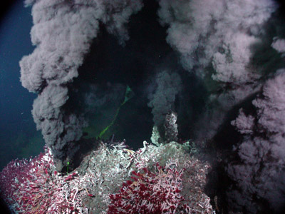
Generally supercritical water works with carbon dioxide and sulfur that also create large deposits of metallic sulfides that are termed Volcanogenic Massive Sulfides (VMS). In very deep water such as that found in the deeper parts of the ocean supercritical water can be exhausted into the open water where it precipitates large clouds of metallic sulfides in a feature that scientists call “Black Smokers

Most of the gold this precipitation by supercritical water is between 100° and 200°C that is about the temperature at which the metamorphic rock slate normally forms. The gold is often found in quartz veins that intrude the beds of Slate.

Another type of gold deposit that can occur as a result of being precipitated from supercritical water is the so-called Carlin type of ore deposit where the gold is disseminated through the rock in specs so tiny they can only be seen with an electron microscope and may consist of this little is one ion of gold.

A similar situation is found in quartzite that has been stained by supercritical water passing through the sandstone in leaving behind a whole suite of minerals that can very often not be seen to the naked eye. This is especially true if the quartzite shows any form of yellow or even better green staining.

Black Smoker with clouds of metal sulfides surrounded by supercritical water
NOAA
If you are finding classy looking quartzite without any staining at all you can be almost sure that it is barren of any mineralization including gold. One of the things you should examine further is any quartzite that has been stained yellow or green. This is especially true if the quartzite is in a contact deposit close to an igneous intrusion where often form a halo around the intrusion. This type of deposit is called a skarn that can contain all kinds of mineralization including gold.

Sunday, January 23, 2011

Gold Occurrences in New York State

Although gold is known to occur in New York State a law dating back to the birth of the United States in 1776 dictates that any gold found in the state will remain the property of the State of New York. The effect of this law that is still on the books has acted as a damper on any efforts to find gold. Even if you were to find gold in your own backyard if you read the fine print on your deed you will find that gold does not belong to you but to the state. Efforts are now being made to change that law to date it is still in effect. Not only gold is affected by this law, but so is silver. Plainly the law says all gold and silver deposits found in New York will remain the property of the state. This law has been amended several times over the years allowing the finder of a gold deposit a period of several years to work his claim.

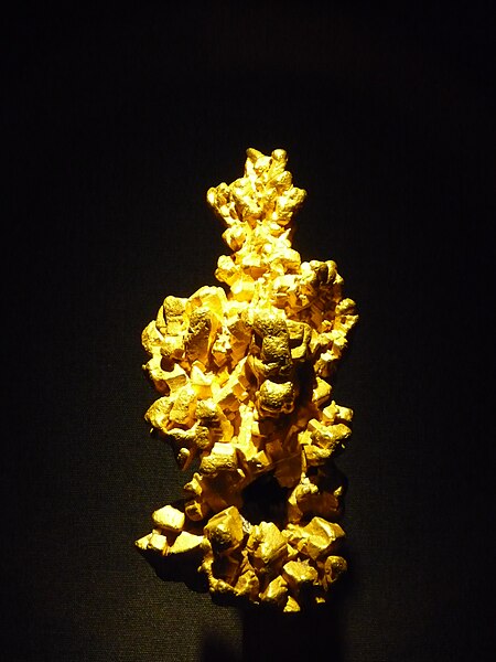
This is what gold looks like in the form of the Latrobe Nugget on display in the London Natural History Museum.
Photo by Gump Stump

Looking at a geological map of New York State it is easy to see that there are several environments in the state that are likely to contain both lode and placer gold. Probably the most likely place where you can find lode gold is in the Adirondacks, and the second most likely place is in the Hudson Highlands, and strangely enough right in New York City. These are areas in New York State where the bedrock is made up of crystalline rocks that may, or may not be the host for gold.

There is a lineation associated with the west bank of the Hudson River called Logan's line that marks the westernmost part of the Taconic orogeny. Anywhere to the east of this line it may be possible to find gold especially in the quartz veins found in the Slate belt of eastern New York along the border with New England.

This is how you pan for gold.  USGS

Two of the counties gathering attention are Columbia and Saratoga counties. Although the particulars of these deposits are not clear from examining the geology found in those counties it is apparent they are probably lode deposits.

Another potential source for gold is found in the conglomerate of both the Schwangunks and Catskills where it was weathered out of high mountain ranges that light to the east. The rocks that are found in the Schwangunks were deposited in the Queenstown Delta, and the conglomerates that are found in the Catskills were eroded from another later mountain range that light even further east. These ancient conglomerates could be the host of fossilized placer deposits similar to the Witwatersrand Reef in South Africa, the world's largest deposits of gold.

It may look like Manhattan, but there is likely to be gold under its streets.
Wikimedia Commons

There is likely to be gold found in placer deposits across the length and width of New York that were brought down by the action of continental glaciers in at least three glaciations in the past 1 million years. Immediately to the north of New York State lies the Abitibi Gold Belt of Québec and Ontario. This extends for over 500 miles from Wawa, Ontario to Val ‘Dor, Québec. The scouring action of the glacier removed any gold that was loose in the soil of these provinces and took it south to be deposited across the width of New York State.

Just to the north of the Pennsylvania State line is the terminal moraine of the last glacier. This is an area that would be no doubt be good for prospecting in the many streams and rivers that cut through the glacial deposits. The action of running water would tend to concentrate any gold that was deposited in this area by the melting of the glaciers.

The plunge pool under Niagara Falls probably contains gold if you can find a way to get it!
Wikimedia Commons

The other big terminal moraine in the state is Long Island, there is the possibility that a small amount of gold was brought down from New England by the glaciers forming deposits in the sand and gravel.

Although you may not get rich hunting for gold in New York State at least there is enough that may be found to at least see what it looks like. Maybe someday the state assembly will change the law about the possession of gold to where the average New Yorker will be able to keep any gold that he finds.