 |
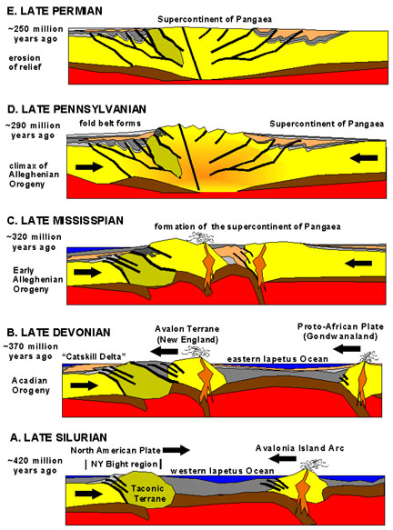
| The earth movements that affected the Appalachian Mountains after the Taconic Orogeny USGS |
During the late Cambrian and early Ordovician a series of
turbidite flows came down the continental slope of the North American
craton. This was the origin of the Roweschist formation. Turbidites are also good
sources of gold ore. There are several
examples of this kind of formation worldwide with the Witwatersrand of South
Africa being the most notable. Much of
the gold ore from Timmins , ON Witwatersrand
has produced around 40% of the entire world’s gold supply in the past 40
years. The gold mines found here are
some of the deepest in the world that now are approaching 13,000 feet deep.
Earth movements associated with the Taconic Orogeny during
the late Ordovician caused this layer of turbidite to be shoved to its present
location close to the Iapetus Suture zone that locally in Connecticut
and New York is called Cameron’s
Line under differing names it reaches to the mountains of western Norway . It is truly one of the largest suture zones
on earth. By definition a suture zone is
also a subduction zone where rocks of oceanic origin are forced under the
continental margin. Cameron’s Line is
about two miles west of the Rowe schist the formation that underlies the
property belonging to the finder of the Whodunit Mine.
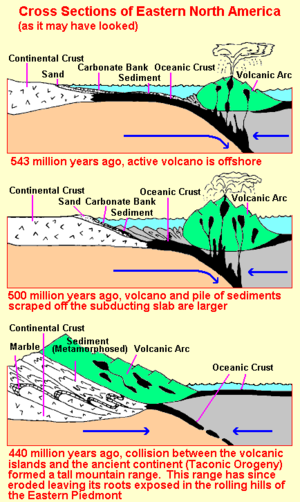
According to the USGS the following illustration graphically
explains the Taconic Orogeny an Alpino type orogeny, a long narrow belt of
mountains that formed the Taconic mountain range. This is the orogeny that initiated the first
of several mountain building events that occurred in the Northern
Appalachians . This is the
orogeny that had the greatest effect on the Litchfield site.
The site itself is composed of a series of turbidite flows
that flowed down the continental slope into a back arc basin behind the island
arc. This was composed of the sand and
mud component illustrated in the first of the illustrations shown of the below
diagram. The Hoosac Schist on the landward
side of Cameron’s line is represented by the portion marked sand. The continental crust is represented by the
Precambrian rock north and west of the site on the landward side of Cameron’s
Line.
Cameron’s Line is where the Hoosac schist and the portion
marked sediment meet in a long suture line that extends from Staten
Island , NY Atlantic Ocean opened during the Mesozoic
and after passing through Ireland ,
Scotland
eventually ends in the mountains of northern Norway .
When the Taconic Orogeny ended the mountains that rivaled
the Himalayas in height were completely eroded away to a
flat plain we know as a peneplain. There
were small mountain building events that occurred during the Silurian that
although they affected the local area were so small as to be hardly noticed. The next big event that affected the eastern
seaboard occurred during the Devonian called the Acadian Orogeny.
The Acadian Orogeny produced a different type of mountain
range that was much broader then the Taconic Orogeny that to geologists is a
Hercyanian type orogeny that was caused when Europe
sideswiped the North American Continent.
It was during this event that the Rowe schist was intruded with molten
magma causing it to become a type of rock called granofels. This action caused many secondary minerals to
be deposited in the schist ilmenite being the most prominent. The event also caused further deformation to
the Rowe schist.
At the end of this orogeny the Rowe schist has stayed above
sea level unlike at the end of the Taconic orogeny as the rocks were eroded
smooth the ocean came back to cover the land with ocean water.
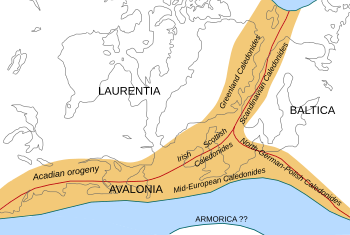 |
| Land affected by the Acadian Orogeny. The original path of Cameron's Line is depicted in red. |
For the most part the only Orogenies that affected the local
area were the Taconic, the Silurian (?) and the Devonian. The later Orogenies affected the lands to the
south and east.